
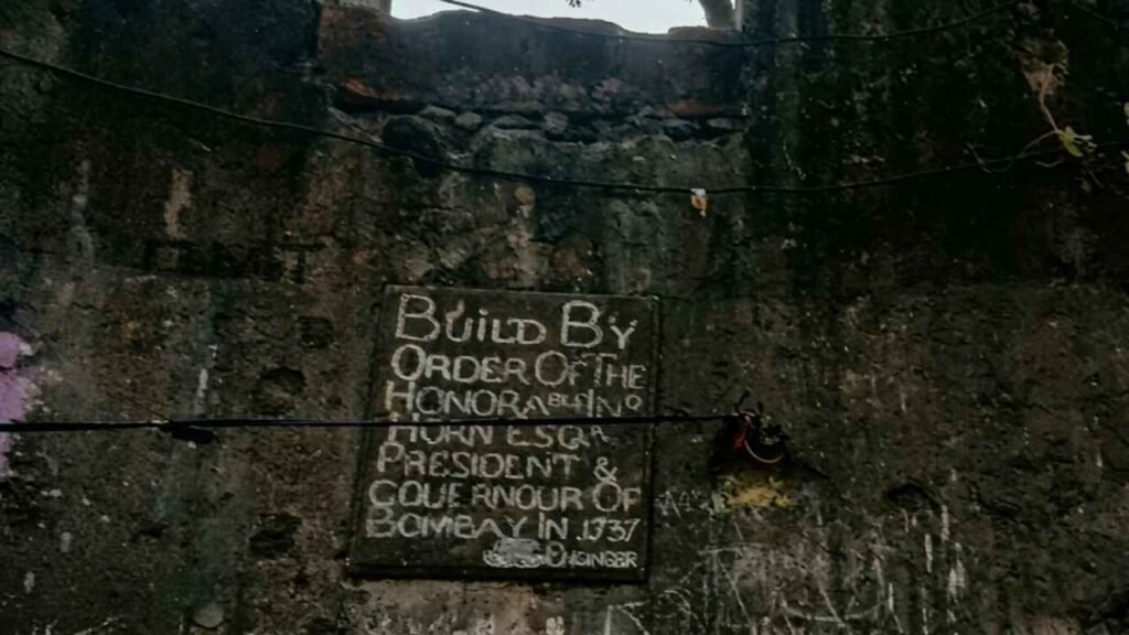
Riwa Fort is not a name Dharavi uses. If you go looking for it, you will have to ask for Kala Killa, the Black Fort, because the people around are not much aware of the name Riwa. That small mismatch says a lot about this forgotten watchtower. The fort has not vanished from Mumbai. The city has simply grown over it and stopped remembering what it was called.
Dharavi had a reputation long before we reached it. Probably the largest slum on the continent, it has been ill-famed for decades, and any sane person, we would have said, would keep away. Then, a few years back, we learnt about a guided heritage walk through the area and joined one fine morning. It was a revelation. The tour changed the way we looked at the slums, and during it we also heard about a small watchtower built of black laterite stone, the Kala Killa.
Given how much we love forts, we could not resist. After the walk, we made sure we went to see it. Riwa Fort is a ruin and takes about ten minutes to see, but its defences still stand strong and the inscription on its wall made the detour worth it. Here is what we found, what the history says, and how to find Riwa Fort yourself.
Riwa Fort: a black watchtower on Dharavi’s old border
Before Dharavi became a neighbourhood, it was marshy land beside the Mithi river, a Koli fishing area that sat between British-held Bombay and Portuguese-held Salsette. The fort was built to watch that line. Our book describes it as a watchtower and a store for ammunition. The name Kala Killa comes from its dark stone: kala means black in Marathi. Sources differ on the stone itself. Our book says laterite, while Wikipedia lists basalt and lime mortar, but every account agrees it is dark and solid.
Who built Riwa Fort, and why in 1737?
The best evidence is the stone plaque on the front wall. It records that the fort was built by order of the Honourable Horne, President and Governor of Bombay, in 1737, and it carries an engineer’s signature. John Horne governed Bombay from 1734 to 1739, so the dates fit. You may see Gerald Aungier credited online, but he governed Bombay in the 1670s, which makes the plaque the safer guide.
The year matters too. In 1737 the Marathas took the Portuguese territory north of Mahim creek, the campaign that gave them Vasai Fort. Heritage writers at Durgbharari read the fort as a precaution by a British administration that was uneasy about the Maratha army next door. That reading makes sense of the timing, though I would call it an interpretation rather than a documented order.
The same Maratha push left its mark across the region. Madh Fort, on Mumbai’s northern edge, faced Maratha attacks in these years, and Belapur Fort in Navi Mumbai tells another chapter of the same story.
Our book says the fort never saw a battle and stayed in British hands from the day it was built. Wikipedia says the Marathas later captured it. We could not find a firm record either way, so treat the fort’s fighting history as an open question.
The mystery of which fort is the real Riwa Fort
Here is a twist most visitors never hear. Three old fortifications stand close together around Sion: one along the Eastern Express Highway, which is the one people call Sion Fort, a small watchtower beside the railway lines, and the Dharavi fort behind the bus depot with the 1737 plaque. In a DNA India column, Rajendra Aklekar describes a long-running dispute over which of them is the original Riwa Fort.
One camp, led by an expert from the state archaeology department, treated the railway watchtower as the real Riwa Fort and the Sion structure as the Black Fort. A later study concluded that Riwa Fort and the Black Fort are the same place, and that the lonely watchtower was once part of Sion Fort. Most old maps place the Riwa name at the Dharavi site. That is the one with the plaque, and the one locals call Kala Killa, so that is the one this post follows.
What you can see at Riwa Fort today
The fort is a miniature structure, and what survives are strong base walls. On the front face sits the stone inscription, surprisingly intact. There seemed to be no way inside. Our book notes that with a little effort you could clamber up through a crack in the front wall, but weeds dominate the place. What remains within is a trench-like hollow full of garbage.
Accounts of the plan differ. Durgbharari describes a triangular fort with two arrow-shaped bastions and a wall of about eight feet. A blogger who climbed in with a resident’s ladder reports three bastions and an underground chamber with a small tunnel. We cannot confirm that chamber, so take it as his account. The Mithi has since moved away from the walls, but one long-time resident told him he remembered the river flowing beside the fort.
How to find Riwa Fort in Dharavi
Directions are the hard part, because the lanes are narrow and the fort has no signboard. Our book’s route is simple: at Sion circle, cross over to Sion East and ask for Kala Killa near the Hanuman Seva Mandal. Other descriptions put it behind the Dharavi bus depot, opposite Mahim Nature Park, down a small lane beside a housing society’s gate. Another places it on a lane off the Sion-Bandra Link Road near the ONGC building.
The descriptions differ because the lanes are easy to confuse, so rely on locals and a map pin. Ask for Kala Killa, not Riwa.
Visiting Riwa Fort: what to expect
It is not a ticketed attraction. It comes under the Maharashtra State Directorate of Archaeology and Museums, but it is poorly maintained and surrounded by homes. There are no facilities, so go with realistic expectations and ten minutes in mind.
Treat it as a lane people live in. Go in daylight, ask politely, and keep to the outside of the walls. We would not advise climbing, since the structure is weathered and the interior is full of rubbish. Early morning in the dry months is the comfortable time. The Mithi nearby is known to flood in heavy rain, so avoid the monsoon.
What to see near Riwa Fort
The guided heritage walk that led us here is still the best way to see Dharavi’s lanes with someone who knows them. Sion Fort is close, and Mahim Nature Park sits opposite the fort’s lane. Mahim Fort stands nearby, and across the creek is Bandra Fort, together marking the old frontier this watchtower once helped guard.
Final thoughts: the fort that fits in ten minutes
This little fort will not give you ramparts to climb or a sea view to photograph. It gives you something stranger: a fort that survived in plain sight, in the middle of one of the world’s most talked-about neighbourhoods, while the city around it forgot its name. If the 1737 frontier story pulled you in, follow the same Maratha-Portuguese line north through Vasai Fort and Ghodbunder Fort.
Save this post, share it with a fellow traveller, and stay tuned for the next fort in the series.