
We were riding along the northern shoreline of Maharashtra, moving through a string of beaches that seemed to grow quieter with every kilometer. Kelve, Satpati, Nandgaon, Navapur, and a few unnamed stretches had already shown us a side of the Konkan that felt far removed from Mumbai’s noise.
Then we reached Shirgaon.
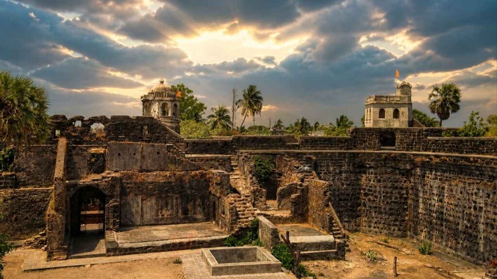
The beach was quiet, the sand largely undisturbed, and the sea looked almost too calm to have once been watched so carefully. At high tide, the water rises towards the old fort walls, reminding you that this was not merely a pleasant coastal settlement. Shirgaon Fort stood here as a watchtower, keeping an eye on vessels approaching through the Arabian Sea.
Today, the fort is part of a peaceful village landscape. Children play around the old walls, the sea keeps its daily rhythm, and the fort itself is in surprisingly good condition. It may not have witnessed a famous battle, but its location and construction tell us much about the network of small coastal defenses that once guarded the Konkan.
Shirgaon Fort at a glance
- Location: Shirgaon village, Palghar district, Maharashtra.
- Distance: Approximately 10 km from Palghar according to the book, although modern travel listings and local accounts may give slightly different distances depending on the route and starting point.
- Setting: Beside Shirgaon Beach and a narrow coastal inlet.
- Type: Coastal lookout tower and defensive fortification;
- Dimensions: Approximately 200 feet by 150 feet, according to the book.
- Walls: Around 30 feet high and 10 feet thick, according to historical descriptions.
- Historical powers: Portuguese, Marathas, and British.
- Maratha capture: 1739, during Chimaji Appa’s Konkan campaign, according to the book and local historical accounts.
- Best experience: Combine the fort with Shirgaon Beach, nearby coastal villages, and the Kelva-Mahim shoreline.
Where is Shirgaon Fort?
Shirgaon Fort is located in Shirgaon village in Palghar district, Maharashtra. It stands close to the beach, with its western side facing a narrow inlet or backwater that stretches a short distance southwards. This setting gave the fort a clear view of the coast and the water approaching the village.
The fort is part of the long coastal belt north of Mumbai, where beaches, creeks, fishing villages, coconut groves, and historic settlements follow one another. Palghar, Kelva, Mahim, Satpati, and Shirgaon all belong to this landscape, although their individual histories are different.
What makes the location particularly striking is the contrast between the fort’s purpose and its surroundings. Today, Shirgaon feels slow and peaceful. In the past, that same quiet shoreline would have been useful to anyone trying to observe ships, protect a landing point, or warn a larger settlement of approaching danger.
A fort built to watch the sea
Unlike a major capital fort or a large military citadel, Shirgaon Fort appears to have been built primarily as a watchtower. The book does not record any major battle or dramatic siege taking place here. Its importance lay in surveillance and support rather than in being the center of a large military campaign.
This is an important distinction. Coastal defense was not created only through large forts with massive garrisons. A network of smaller posts, lookout points, creek defenses, and outlying bastions made it possible to monitor a long shoreline.
Shirgaon occupied a useful position within that network. From the fort, guards could observe the sea and the inlet, while the surrounding settlement could serve as a base for local movement and supplies. The fort may have been modest compared with Arnala or Vasai, but its location allowed it to contribute to a broader defensive system.
The Maharashtra Tourism Department describes Shirgaon Fort as a vantage point associated with Chhatrapati Shivaji Maharaj and notes that the Portuguese later renovated and expanded the fort while retaining elements of its original brick and red-stone construction.
The early history of Shirgaon
The early history of Shirgaon is not entirely consistent across available sources. Some modern accounts attribute the earliest fort to the Yadavas of Devgiri, dating it to the 13th century, while the book presents Shirgaon mainly as a coastal watchtower whose better-documented history belongs to the Portuguese and Maratha periods.
The fort is also said to have passed through the hands of Gujarati Muslim rulers, the Bahamani dynasty, and the Ahmadnagar Sultanate before Portuguese expansion along the northern Konkan coast. These transitions reflect the changing political control of the region, where coastal settlements were linked to inland kingdoms, ports, and sea routes.
Because the surviving sources differ on the original builder and date, it is better to present the early history with caution. What is clearer is that the site was strategically useful before and during the Portuguese period and that the fort was later strengthened and incorporated into their coastal network.
Portuguese control
By the 16th century, the Portuguese had established themselves along large sections of the western coast. Their settlements were not limited to major centers such as Daman, Bassein, or Goa. They also depended on smaller forts and outposts to watch creeks, protect ports, and control movement between coastal villages.
Shirgaon became one of these smaller positions. The Portuguese renovated the fort, increasing its area while retaining parts of the earlier construction. This created a tight defensive structure with thick walls, corner towers, and a strong entrance.
The book describes the fort as an oblong structure about 200 by 150 feet. Its walls were about 30 feet high and 10 feet thick, with towers at the corners and another bastion close to the entrance. At high tide, the waters of the inlet washed the western side, adding a natural defensive feature.
The fort did not need to be enormous. Its strength came from its position, its thick walls, and its ability to observe the coast.
Chimaji Appa and the Maratha capture
The political situation along the north Konkan coast changed in the 18th century. The Marathas began a determined campaign to remove Portuguese control from several forts and settlements. Peshwa Baji Rao I’s brother Chimaji Appa led this campaign and captured a number of Portuguese positions from 1737 to 1739.
According to the book, Chimaji Appa captured Shirgaon Fort in 1739, along with Katalvada, Dahanu, Kelva, and Tarapur. Modern accounts commonly place the Maratha capture in January 1739, after the campaign against Vasai had progressed.
There are differences in the exact chronology across secondary sources, so the larger historical context is more important than assigning a dramatic battle to Shirgaon itself. The fort formed part of the Portuguese defensive chain that the Marathas gradually dismantled.
Unlike Tarapur or Vasai, Shirgaon does not seem to have been the scene of a famous standalone siege. Its capture was more likely part of the wider transfer of Portuguese coastal possessions to the Marathas.
The Marathas then repaired several forts in the region and used them as part of their own coastal system. Shirgaon’s continued value came from its position beside the sea and its ability to watch the approaches to the coast.
The British period
In 1818, after the defeat of the Maratha power in the Third Anglo-Maratha War, Shirgaon Fort came under British control.
By then, the fort’s importance as a frontline military position had already declined. Improvements in military technology, changing political boundaries, and the British administrative system altered the role of many smaller forts across the Konkan.
Like several coastal forts in Maharashtra, Shirgaon gradually became part of the local landscape rather than an active military center. Its walls remained, but the soldiers, supplies, and constant surveillance associated with its earlier life disappeared.
What remains of Shirgaon Fort today?
The best surprise at Shirgaon Fort is the condition of its outer structure. The book describes most of the fortifications as being in excellent order, with walls that remain about 30 feet high and 10 feet thick.
The fort has:
- An oblong layout.
- A strong entrance.
- Two large bastions flanking the entrance.
- Three towers at the corners.
- A further bastion at the remaining corner.
- Remains of internal buildings.
- A well that once supplied sweet water.
- Views across the sea and the coastal inlet.
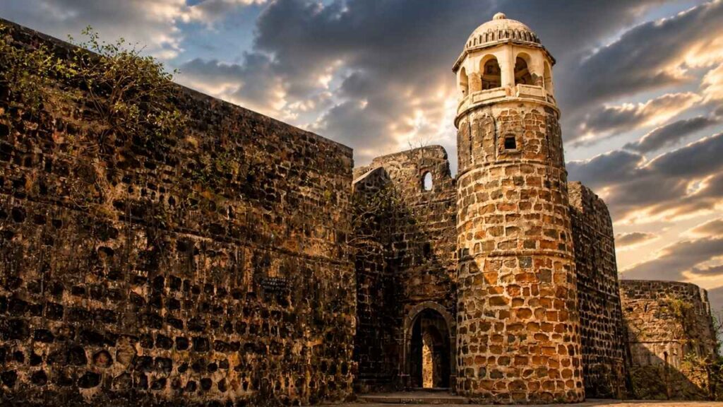
The western face is especially striking because it meets the water at high tide. The inlet or backwater creates a natural separation between the fort and the sea, making it easy to imagine why the location was selected.
Inside, buildings for the garrison and stores once occupied more than half the area. Today, most of those structures have disappeared, leaving open ground, traces of old foundations, and the surviving fortification walls.
The old travellers’ bungalow near the fort has also served as a school. The book mentions schoolchildren playing around and inside the fort and readily showing visitors around. That detail gives Shirgaon a warmth that many abandoned forts lack. The fort is not entirely cut off from everyday life. It continues to exist alongside the village.
Walking around the fort
A visit to Shirgaon Fort is best taken slowly. This is not a place where you rush through a checklist of monuments. The pleasure lies in noticing how the structure meets the coast.
Begin at the entrance and look at the thickness of the walls. The gateway was designed to be defensible, with large bastions on either side. From there, walk along the ramparts if access and local conditions permit.
The corner towers offer a sense of the fort’s layout. They were not merely architectural features; they were observation points and defensive positions. From the higher sections, the view opens to the Arabian Sea, the inlet, the village, and the surrounding greenery.
The well inside the fort is another reminder of how such a structure functioned. A fort needed water, food, storage, and accommodation to remain useful. Walls alone could not sustain a garrison.
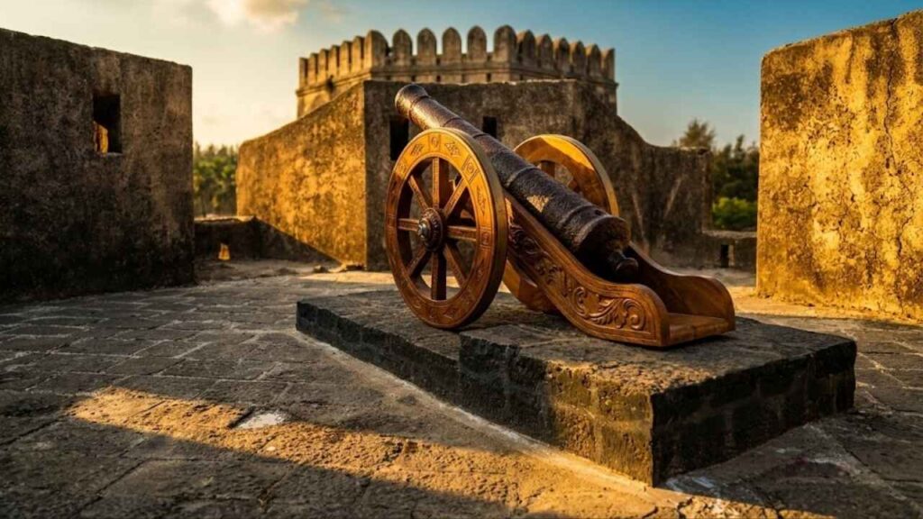
Look out for the contrast between the old red and dark stone surfaces, vegetation growing around the ruins, and the everyday life outside the walls. A child walking to school or playing near the fort is as much part of the present story as the cannons and bastions are part of the past.
Shirgaon Beach
Shirgaon Beach is an important part of the visit. The book describes it as quiet and serene, with clear water, lush Suru trees, and relatively unspoiled sand.
The beach is not just a place to add after seeing the fort. It helps explain the fort’s location. Stand near the shoreline and consider how different the scene would have looked when guards watched the water for unfamiliar sails.
At high tide, the sea reaches the walls of the fort. This makes the relationship between the fort and water especially visible. The fort was not built beside the sea by accident. Its entire purpose was connected to what moved across that sea.
The beach also gives you time to appreciate the fort from the outside. From a distance, the walls appear more imposing than they may feel once you enter. Their height and thickness become easier to understand when seen against the open shoreline.
How to reach Shirgaon Fort
By rail: The nearest major railway station is Palghar. From Palghar, local buses, shared auto-rickshaws, and private vehicles can take you towards Shirgaon. The book mentions regular buses serving the Palghar-Shirgaon area.
By road: Shirgaon can be reached by road from Palghar, Kelva, Mahim, and other nearby coastal settlements. If driving from Mumbai, the route takes you north along the western side of Maharashtra before turning towards the coast.
Route distances and local road conditions can change, so check navigation directions before leaving and confirm the final approach with local residents.
Best time to visit
The cooler months from October to March are generally the most comfortable for visiting Shirgaon Fort and the surrounding beaches. The weather is better suited to walking, photography, and spending time outdoors.
You can visit the fort for most of the year, but the monsoon brings heavy rain, slippery surfaces, and rougher coastal conditions. The landscape becomes greener, but access around the walls may be less comfortable.
Early mornings and late afternoons are ideal if you want softer light and fewer people on the beach. Late afternoon also gives the fort a warmer appearance, especially when the sun falls across the stone walls.
Nearby places to explore
A Shirgaon visit can form part of a wider coastal itinerary:
- Palghar: The nearest major town and transport base.
- Kelva Beach: A popular coastal destination with its own historic fort remains nearby.
- Mahim: Another historic coastal settlement with traces of a fort.
- Satpati: A fishing settlement that helps you experience the living maritime culture of the Palghar coast.
- Tarapur Fort: A larger and more historically documented Portuguese fort farther north.
- Chinchani Beach: A quiet beach that can be combined with Tarapur Fort.
- Dahanu and Bordi: Further north, offering beaches, orchards, and additional heritage stops.
This combination makes the region particularly interesting for anyone following the history of north Konkan’s coastal defenses.
Practical tips for visiting Shirgaon Fort
- Wear comfortable footwear, as the ground around old forts may be uneven.
- Carry water, especially if you are visiting during the warmer months.
- Respect the village and any school or local activity around the fort.
- Do not climb damaged walls or enter unsafe sections.
- Avoid littering the beach or fort grounds.
- Ask locally before photographing people or entering areas that appear privately used.
- Check current access conditions before traveling, because the fort is part of a living village environment rather than a fully managed tourist complex.
- Combine the fort with Shirgaon Beach and nearby coastal sites instead of treating it as a quick stop.
Final thoughts: a quiet fort with an important role
Shirgaon Fort is not remembered because a famous battle was fought within its walls. It is important for another reason. It represents the many smaller coastal posts that helped kingdoms and colonial powers watch, defend, and control India’s western shoreline.
Its thick walls, corner towers, old well, and sea-facing position tell us that the fort once had a practical purpose. Its connection with the Portuguese, Marathas, and British places it within the larger political story of the Konkan. It’s less hard of an identity, because it’s in a contemporary setting and there are children playing nearby and the sea is going beyond the walls.
Standing on Shirgaon Beach and looking at the fort, one feels that the past is not far away. The watchtower might be long gone, but the view it was built to protect remains. The sea still arrives, the inlet still changes with the tide, and the old walls still stand quietly at the edge of it all.
Save this post for your next north Konkan journey, share it with someone who loves forgotten forts, and stay tuned for the next story in the Sea Forts of India series.