
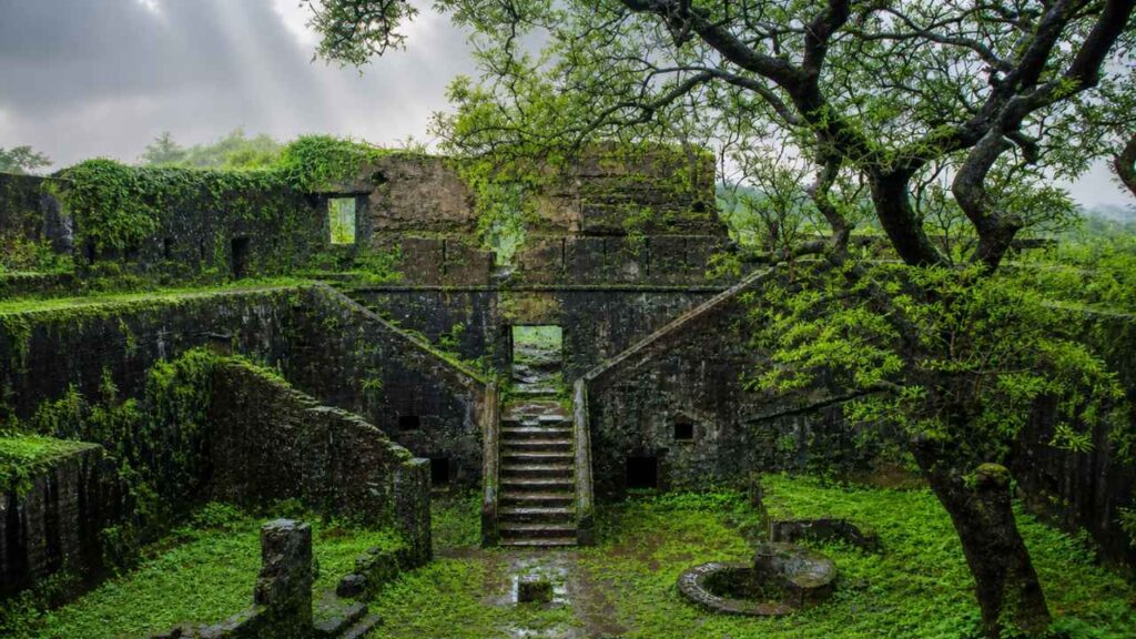
The road to Mahim Fort does not feel like the approach to a historic monument.
There is no dramatic climb, no long view of battlements, and no sudden glimpse of a fortress rising above the coast. Instead, the route winds through the ordinary life of the village—houses close to the road, people going about their day, small shops, passing vehicles, and the familiar sounds of a settlement that has grown around the remains of an older world.
Then, almost without warning, the fort appears.
What first looks like a low, weathered wall turns out to be part of an old Portuguese coastal stronghold. The structure is smaller and quieter than the great forts of Vasai or Arnala, but its position tells you why it was built. Mahim stands near the creek and the sea, within the defensive landscape that once connected Vasai, Kelve, Shirgaon, Tarapur, and the other Portuguese positions along the north Konkan coast.
In the book, I describe Mahim as one of those forts that can be overlooked precisely because it has become part of everyday life. There is no sense of arriving at an isolated monument. The fort is woven into the village, its old walls standing beside newer buildings and familiar routines. That closeness makes the visit more intimate, but it also makes the ruins feel vulnerable.
The Portuguese did not build Mahim for ceremony. They built it to watch the creek, observe coastal movement, and protect the routes leading towards their larger strongholds. Soldiers would have looked out from these walls towards the water, waiting for boats, messengers, traders, or enemies.
Today, the fort is quieter.
The guns are gone. The garrison has vanished. Much of the original structure has been lost to time. Yet the surviving masonry still holds the outline of its purpose. Stand beside the old wall and look towards the coast, and the fort begins to reveal itself—not as a grand monument, but as one small and necessary link in the Portuguese defense network of the Konkan.
A small fort with a strategic view
Mahim Fort was never intended to rival Vasai in size or Arnala in drama. Its value lay in its position. The fort stood near the creek and coastal routes, allowing the Portuguese to monitor movement along the shore and maintain communication with nearby positions.
From Mahim, the Portuguese could observe the local waterway and support the wider chain of forts protecting their northern Konkan territories. The fort’s importance was therefore connected to the forts around it. It was part of a system in which smaller posts watched the coast while larger centres such as Vasai served as military and administrative headquarters.
That network eventually came under pressure during the Maratha campaigns of the 18th century. When Chimaji Appa moved against Portuguese power in the north Konkan, forts such as Mahim became important because every captured outpost weakened the larger system surrounding Vasai.
Mahim Fort at a glance
- Location: Mahim village, Palghar district, Maharashtra.
- Setting: Mahim Creek and Mahim Beach.
- Type: Small coastal fort and defensive outpost.
- Historic region: Kelve-Mahim, north Konkan.
- Dimensions of the fort: Approximately 80’ x 80’ as described in the historical book.
- Surviving features: Parts of the fortification, the eastern entrance, a battery, a neglected well, and traces of former garrison structures.
- Historical powers: Local Naik chiefs, Gujarat rulers, Portuguese, Marathas, and British.
- Portuguese period: From the 16th century.
- Maratha capture: January 1739, during the wider campaign led by Chimaji Appa.
- Present condition: Highly dilapidated and overgrown.
- Nearby places: Mahim Beach, Kelve Beach, Kelve Fort, Alibaug Fort, Panburuj, and Shirgaon
Where is Mahim Fort?
Mahim Fort is located in Mahim village in Palghar district, Maharashtra. It is near Mahim Creek, close to the coast and Mahim Beach.
This is not the Mahim Fort of Mumbai. The two forts share the same name but are in different places and have different historical contexts. The Palghar fort is part of the old Kelve-Mahim coastal belt, while the Mumbai fort stands on the city’s Mahim Bay.
The distinction is important when planning a visit. Search for Mahim Fort Palghar or Mahim Fort near Kelve rather than simply searching for Mahim Fort.
The fort lies in a village setting, not within a formal urban heritage precinct. It is set on the beach, in the creek, in houses, on local roads, in vegetation, and in everyday coastal activity. This gives the site a quiet and unpolished character.
A small fort beside the creek
The location of Mahim Fort tells us much about its original purpose.
The western side of the fort faced Mahim Creek, whose waters provided a natural defensive edge. The other sides were protected by fortification walls and the layout of the settlement around it. From this position, the garrison could observe movement along the creek and the adjoining coast.
This was not a major capital fort. It was a small coastal outpost, probably intended to support the larger defensive network of the region.
Such outposts were important because a coastline could not be protected by one large fort alone. Smaller forts, batteries, stockades, and watchpoints helped monitor creeks and landing places. They also provided storage, shelter, and artillery support.
Mahim’s location between the creek and the coast made it useful for this purpose. Although the fort itself was compact, it was connected to a wider system that included Kelve, Alibaug, Panburuj, and other smaller coastal defenses.
The early history of Kelve-Mahim
The history of Mahim Fort is tied closely to the history of the surrounding Kelve-Mahim region.
According to the account in the book, the Naik chiefs controlled Kelve-Mahim from the early 13th century. Later, the region came under Bhimdev, a ruler associated with Mahim in the Bombay area.
Around 1350, the Delhi Sultanate conquered the region. By about 1400, the Gujarat rulers had established control. Every change witnessed the importance of the coastal belt and its connection with inland territories.
The region had access to creeks, beaches, and sea routes. These natural features supported movement and trade, but they also made the coast vulnerable to attack. Control over Kelve-Mahim meant control over a small but useful section of the north Konkan shoreline.
The fort’s later history cannot be separated from this geography. Its walls were built not in isolation but as part of a landscape shaped by water, trade, and changing political power.
Portuguese control and coastal trade
The Portuguese took control of the Kelve-Mahim region around 1532. Their interest was not only military. Trade played a major role in their expansion along the west coast of India.
The book mentions the fine muslin that travelled from inland centres such as Kandahar in the Deccan, Daulatabad, and Burhanpur. These goods were transported via networks connecting inland markets to coastal ports. The Portuguese built a string of forts and outposts to protect these interests. The defenses controlled movement, secured trade routes, and prevented rival powers from using the creeks and landing points.
Mahim Fort was one of the smaller forts in this network. It wasn’t as big as Vasai or as imposing as Arnala, but it served a practical purpose. Its garrison and artillery helped to keep an eye on the water and protect the settlement.
The book records that the fort was guarded by 15 pieces of ordnance and a garrison of approximately 60 soldiers. A stockade some distance away was placed under a captain with 30 men.
These details provide a sense of how the fort functioned. It was not merely a wall around a village. It had soldiers, guns, stores, and supporting defensive positions.
The Mughal attack of 1612
Portuguese control was challenged by the Mughals.
In 1612, Mughal forces attempted to take Mahim Fort but did not succeed. The Portuguese continued to hold the position.
The failed attack demonstrates that even a small coastal fort could attract the attention of a powerful empire. The fort’s value came from its location rather than its size.
A fort beside a creek could monitor boats and protect a landing point. It might also warn nearby settlements and larger forts in advance. For the Portuguese, these smaller posts were essential links in a defensive chain.
Mahim’s garrison would have had to maintain the walls, artillery, supplies, and water source. The fort’s well was especially important because a military post could not function for long without a dependable supply of fresh water.
Chimaji Appa and the Maratha capture
The most important chapter in the later history of Mahim Fort came in 1739.
By this time, the Marathas were mounting a determined campaign against the Portuguese possessions in the north Konkan. Chimaji Appa led the effort to capture a series of Portuguese forts and settlements.
The campaign included Dahanu, Tarapur, Shirgaon, Kelve, Mahim, and eventually Vasai. The aim was to shatter the Portuguese control of the coast and bring these territories under the rule of the Marathas.
The historical account in the book states that Chimaji Appa attacked Mahim in January 1739. The Portuguese resisted for a considerable time but eventually surrendered. The Maratha flag was then raised over the fort.
Some secondary accounts place the surrender of Mahim on 20 January 1739, while the broader campaign continued through the following months. The exact chronology varies across sources, but the larger story is clear: Mahim changed hands during the major Maratha campaign against Portuguese power in north Konkan.
Unlike Tarapur or Vasai, Mahim is not remembered for a long, famous siege of its own. Its importance lies in being one of the coastal positions absorbed into the Maratha kingdom during this wider military movement.
The British period
Mahim Fort remained with the Marathas until 1818.
After the defeat of the Maratha power, the British took control of the forts and territories of Maharashtra.
By the time of the British survey, Mahim Fort was described as being of inconsiderable strength and size. This was a practical assessment of its condition and military capacity. Compared with the large forts that dominated the coast, Mahim was a small enclosure with limited defenses.
Its strategic value had also declined. Changes in military technology and the consolidation of British power reduced the importance of many smaller coastal posts.
The fort gradually became part of the surrounding village rather than an active military station. Its walls remained, but the garrison, guns, stores, and regular surveillance disappeared.
What remains at Mahim Fort today?
Mahim Fort ruins are not grand but still helpful in understanding the original layout.
The historical description records the fort as an enclosure measuring approximately 80 feet square. Its fortification walls were around 5 feet high and 3 feet thick, with a surviving section measuring about 28 feet. The main gateway was on the eastern side.
The fort once contained:
- A small garrison.
- Storage space.
- A neglected well.
- A battery.
- A casemate or bombproof chamber reportedly capable of holding ten guns.
- An outer wall of loose stones on three sides.
- A western edge protected by Mahim Creek.
Today, many of these features are difficult to identify because of neglect and vegetation. The fort is deeply overgrown, and parts of the structure are in poor condition.
There is no great interior to explore. Instead, you find fragments: a piece of wall, traces of the old entrance, overgrown ground, and the remains of a defensive structure that has slowly become part of its surroundings.
The condition may initially feel disappointing. But the limited remains also make the fort an honest example of what happens to smaller military sites after their strategic purpose disappears.
The old battery and casemate
The battery was one of the most important parts of Mahim Fort.
Historical descriptions mention a casemate or bombproof chamber below the battery, believed to have accommodated ten guns.
A covered artillery position provided protection to both the guns and the soldiers operating them. It also allowed the garrison to defend the creek and coastline without exposing every gun position to direct attack.
The fort’s defensive design was practical rather than monumental. The creek protected one side, while the walls and artillery guarded the remaining approaches.
The well was equally important. A fort might survive an attack, but without water it could not support its garrison. The presence of a well suggests that Mahim was designed for sustained occupation rather than only brief observation.
Even though the battery and casemate are difficult to appreciate today, they help explain why a fort of this size could still hold a meaningful defensive role.
Mahim Creek and the coastal setting
Mahim Creek is central to the story of the fort.
The creek was not simply a scenic feature. It shaped the fort’s location, influenced movement, and created a natural boundary along the western side. The water also connected the fort to the wider web of coastal trade and defense.
Today, standing near the creek, one can imagine boats moving through the water and soldiers watching the approaches. The landscape would have been busier in the past, with traffic connected to fishing, trade, transport, and military supply.
The creek also explains why Mahim Fort should be understood as a coastal outpost rather than an inland fort. Its purpose depended on what happened on the water.
Mahim Beach
Mahim Beach lies near the fort and adds an important travel dimension to the visit.
The Palghar district administration describes Mahim Beach as a popular sunset point and notes the presence of Mahim Fort.
The beach gives you space to step back from the fort and see how it fits into the coastal landscape. From the shoreline, the surviving walls appear modest, but their position becomes clearer.
The fort was built to watch the coast. The beach allows you to look at the same broad shoreline that would once have been part of the garrison’s field of view.
Mahim Beach is not merely an add-on to the fort. It is part of the experience. The fort provides the history, while the beach provides the setting.
Mahim Fort and the nearby forts
Mahim Fort was one part of a broader network of coastal defenses.
Kelve Fort
Kelve Fort stood near the mouth of Danda Creek. The book describes it as a small insulated fortification located west of the coast. It is now in ruins, and access has historically been difficult.
Its bastions offered views of the sea and the surrounding Suru forest. Kelve and Mahim were close enough to be understood as connected positions within the coastal defense system.
Alibaug Fort
Alibaug Fort was a separate small battery in the Kelve-Mahim group. Its structure and access arrangements will be covered in a separate post. The fort is particularly interesting because its approach was closely connected to the changing tide.
That high-tide and low-tide story belongs to Alibaug Fort, not Mahim Fort.
Panburuj
Panburuj stood near the mouth of the river and functioned as another coastal battery. It was divided into three sections, with projecting batteries at the ends and a reservoir in the center.
Panburuj demonstrates how smaller artillery positions supported the main fortifications.
Shirgaon Fort
Shirgaon Fort lies farther north and was primarily a watchtower. Its walls are considerably more substantial than those of Mahim Fort, and it offers another example of a small coastal post built to observe the sea.
Together, these forts show that the north Konkan coast was defended through a network rather than one continuous wall.
How to reach Mahim Fort
By rail: The nearest practical railway access is through Palghar and nearby local stations. From Palghar, you can continue by bus, shared auto-rickshaw, taxi, or private vehicle towards Mahim village.
By road: Mahim is connected by road with Palghar, Kelve, Shirgaon, and other coastal settlements. If travelling from Mumbai, follow the route north towards Palghar and then continue towards Mahim Beach.
The last section of the journey may pass through local village roads, so it is useful to confirm the final approach locally.
Access and safety
Mahim Fort is not a fully restored or extensively managed monument. Current access may vary because of repairs, weather, vegetation, local use, or structural conditions.
Ask local residents about the safest way to approach the fort. Do not climb damaged walls, enter unstable sections, or walk through dense overgrowth.
Do not attempt to reach the fort through the creek. The water beside the fort is part of its setting, but it should not be treated as an access route.
Best time to visit Mahim Fort
The cooler months are more comfortable for visiting Mahim Fort, walking around Mahim Beach, and exploring the surrounding coastal area.
Early morning and late afternoon are the best times of day. The light is softer, the beach is more pleasant, and the fort’s walls photograph better.
Mahim Beach is particularly appealing towards sunset, but plan your fort visit during daylight. Because the structure is overgrown and partly damaged, it is not advisable to explore after dark.
The monsoon can make the surroundings wet and slippery. Vegetation may become denser, and the creek may be rougher. If you visit during the rains, take extra care and avoid climbing the walls.
The visit should not be planned around high tide or low tide entrances. Those details belong to Alibaug Fort and should not be applied to Mahim Fort.
Practical tips for visiting
- Search for Mahim Fort Palghar to avoid confusing it with Mahim Fort in Mumbai.
- Ask locally about the current route and access.
- Visit during the day.
- Wear solid shoes suitable for rough ground. Water to drink, sun protection.
- Do not climb on the weak or crumbling parts of the fortification.
- Look out for heavy vegetation and the creek.
- Do not trespass on private property or restricted areas, respect local homes and residents.
- Do not litter the beach, creek, or fort grounds.
- Combine the visit with Mahim Beach, Kelve Beach, or other north Konkan forts.
- Keep expectations realistic. This is a small and heavily dilapidated fort, not a restored monument.
- Check current local conditions before travelling, especially during or after the monsoon.
Is Mahim Fort worth visiting?
Mahim Fort is worth visiting if you enjoy quiet historic places and are willing to look beyond grand architecture.
The fort has limited remains. You will not find a large complex filled with intact buildings, ornate gateways, or clearly marked exhibits. Time, vegetation, and neglect has taken a lot of the structure.
But the fort is another experience. It demonstrates how a small coastal outpost operated within a larger network of defenses. It is important for its location on a creek, its battery, its garrison history, and its association with Portuguese and Maratha rule, though it is physically small.
It becomes more rewarding when you combine a visit here with Mahim Beach and the nearby coastal forts. Together, they reveal a shoreline that was once jealously guarded and fiercely contested.
Final thoughts
A fort of the ocean, Mahim Fort is small, but its history goes back many centuries.
The region was controlled by local chiefs, Gujarat rulers, the Portuguese, the Marathas, and the British. The fort once had soldiers, guns, stores, a battery, and a well. It resisted Mughal pressure and eventually changed hands during Chimaji Appa’s campaign against Portuguese power in 1739.
Today, the fort survives in a much quieter form. Its walls are low, its interior is overgrown, and its role is no longer military. But Mahim Creek still flows beside it, and the coast still stretches beyond the beach.
That is what makes Mahim Fort worth remembering. It is not a grand monument competing for attention. It is a small piece of the north Konkan shoreline, carrying the story of how trade, geography, and power shaped India’s western coast.
Save this post for your next north Konkan journey, share it with someone who enjoys forgotten forts, and follow the Sea Forts of India series for the next story along the coast.