
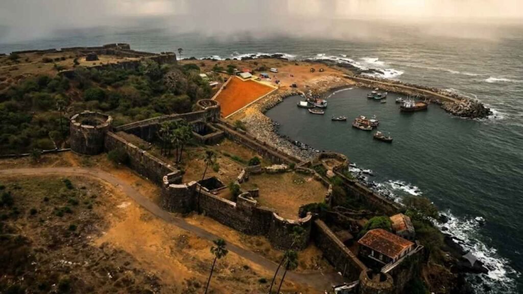
Aksa Beach became famous because of a song. The fort behind it never got one.
That is the odd thing about Madh Fort. It stands at the southern end of Madh Island in northern Mumbai, a short distance from a beach that now fills with weekend crowds, yet few of those crowds ever look at it. The book Sea Forts of India records how Aksa, a little-known beach until a Bollywood hit put it in the spotlight, suddenly began drawing tourists. We were among them. One fine morning we went for the beach and for the fort that lay close by.
We never got inside. Entry into the fort is not allowed, so we walked around its walls instead. As it turns out, that is how most people meet this place: from the outside, looking up.
Madh Fort in brief: Madh Fort, also called Versova Fort, is a Portuguese coastal fort on Madh Island in northern Mumbai. It watched the creek between Madh and Versova. The Marathas took it from the Portuguese in February 1739, and it is now under military control, so visitors normally see it only from outside.
Madh Fort: a watchtower at the mouth of a creek
Madh was once an island, and reclamation has since joined it to the mainland near Malad. Madh Fort sits on a rocky outcrop at the island’s southern tip, where a creek roughly 1,000 to 1,200 feet wide separates Madh from Versova. Sea surrounds it on two sides and land on the other two, according to Durgbharari’s guide to the fort.
The book calls it a tiny fort built as a watchtower, with a commanding view of the Arabian Sea, the Marve Creek, Mumbai’s tall skyscrapers and sailing ships. That tells you what it was for. Sea trade moved past this point, and the fort kept an eye on it. The book is honest that such a watchtower barely features in the pages of history.
Who built Madh Fort, and when?
The Portuguese built it, but the date is slippery. The book gives the 16th century in its history text and the 17th in its summary box. Durgbharari says the early 16th century in one place and 1600 in another.
The archaeologist Mayur Thakare, writing in a study of Madh Island and Versova, estimates that the surviving original structure dates to the second half of the 17th century. He notes that a traveller mentions a fort at Versova in 1695, while a Portuguese survey of 1635 names none. I would say the Portuguese built a fort here between the early 1500s and the late 1600s, and that the walls you see today point to the 17th century.
By 1728 it was not an impressive posting. A Portuguese report described a dilapidated fort with a garrison of about fifty men and ten cannons, only two of them serviceable.
Four attacks and a retreat by boat
The Marathas came for Madh Fort more than once. According to Thakare, the first assault in April 1737 failed, as did a second in May. A third attempt in June or July 1737 turned into a siege of roughly 28 days, during which the Portuguese built a water reservoir inside. It also failed.
The fourth attack, in February 1739, succeeded. Maratha guns bombarded the fort and destroyed its parapet. The Portuguese garrison withdrew by boat on 18 February after destroying its remaining artillery, and Bombay Council minutes of 21 February record the abandonment.
Madh was one piece of a much larger campaign. Chimaji Appa’s drive for the North Konkan reached its biggest prize at Vasai in May 1739, and if you have read our post on Vasai Fort, you know how that story ends. Thakare adds that the Marathas also repaired and enlarged older Portuguese forts at Thane and Ghodbandar and built new ones at Dharavi and Arnala. You can follow two of those threads in our posts on Ghodbunder Fort and Arnala Fort.
After 1739: Yashwantgad, a prison and a film set
The Marathas repaired and enlarged Madh Fort. Thakare suggests they renamed it Yashwantgad, a name that appears in Peshwa records from 1739.
For the British period, the sources disagree. The book says the fort passed to the British in 1818, along with the other forts of Maharashtra. Wikipedia’s article on Madh Island, citing a military history, says the British occupied Salsette, Thane, Versova and Karanja in 1774. Durgbharari adds that under the British the fort served as a prison.
Its later life is stranger. The book notes that Madh drew film directors long before the song and names Love Ke Liye Kuch Bhi Karega and Mard as films shot here. Durgbharari says the fort is used for filming today.
What you can see at Madh Fort today
The book describes a fort fortifying about four acres, with strong defences on all sides and eight round bastions: four at the corners and four in the middle of each wall. Inside, it says, the fort is dilapidated.
Other accounts do not agree on the outline. One describes a seven-sided plan with a large round bastion in the middle, and Thakare describes a large pentagonal bastion at the core. From outside, it is hard to settle. Durgbharari adds that the walls rise 20 to 25 feet with gun openings and that the fort has two gates. The sea-facing gate is reportedly sealed with stone and carries a carved serpent above it.
On the southern face stands the Killeshwar temple, dedicated to Shiva and said in the book to be the fort’s main deity. The book notes that the wall near the temple looks weaker and broken in places and suggests the temple may have been placed there to strengthen a weak link. That is the book’s reading, not a documented fact.
About half a kilometre before the fort, in the village, stands a Ganesha temple said to date from the Peshwa period. A reservoir with stone steps lies beside it.
Visiting Madh Fort: what to expect
Plan for the outside only. The fort is under armed forces control, and sources differ on whether that means the Air Force or the Navy. Entry needs permission, and Durgbharari says photography is prohibited. In another account the door was locked on an ordinary day.
The walk around the walls of Madh Fort takes about 30 to 45 minutes, so treat it as one stop in a Madh Island outing rather than the whole day.
How to reach Madh Fort
The book places the fort about 28 km north of Mumbai.
- By rail: Malad is the nearest railhead.
- By bus: BEST buses connect Madh Island with other parts of Mumbai. Route 271 runs from Malad West to Madh village, about 15 km.
- By road: From Mumbai, take the Western Express Highway to Malad, then follow the road towards Aksa. Wikipedia notes the Madh road is often in poor condition in the monsoon.
- By ferry: A ferry crosses the creek from Versova to Madh Jetty in about 15 minutes, according to one guide. Auto-rickshaws wait at Madh Jetty and the Harba Devi bus stop.
- By air: Mumbai is the nearest airport, about 20 km away.
Best time to visit Madh Fort
The book says you can go year round. One guide recommends November to February for comfortable weather. The monsoon is the wrong time: the road suffers, and the approach is uneven, rocky ground.
- Ask before you enter. Do not try to climb walls or go through gates.
- Check the photography rules. One source says photography is prohibited.
- Respect the village. The fort is surrounded by fishing communities.
- Carry water and go in the morning, as we did, before the beach crowds arrive.
What to see near Madh Fort
The book lists the Killeshwar temple, Aksa Beach and Danapani Beach. Madh Island also has Erangal and Madh beaches, and Durgbharari mentions the Harbadevi temple on a hill in Madh village. Across the creek, Versova Beach is a short ferry ride away.
Final thoughts: the fort behind the beach
Aksa has its song. Madh Fort has the better story: a Portuguese watchtower with a garrison of fifty, four Maratha attacks, a retreat by boat and a long afterlife as a prison and a film location. You cannot walk inside, but you can walk around it, and that is enough to understand why it stood here.
Save this post, share it with a fellow traveller, and stay tuned for the next fort in the series.
Fascinating coastal fort history tucked right alongside Mumbai—easy to overlook how much strategic maritime drama unfolded around Versova Creek.