
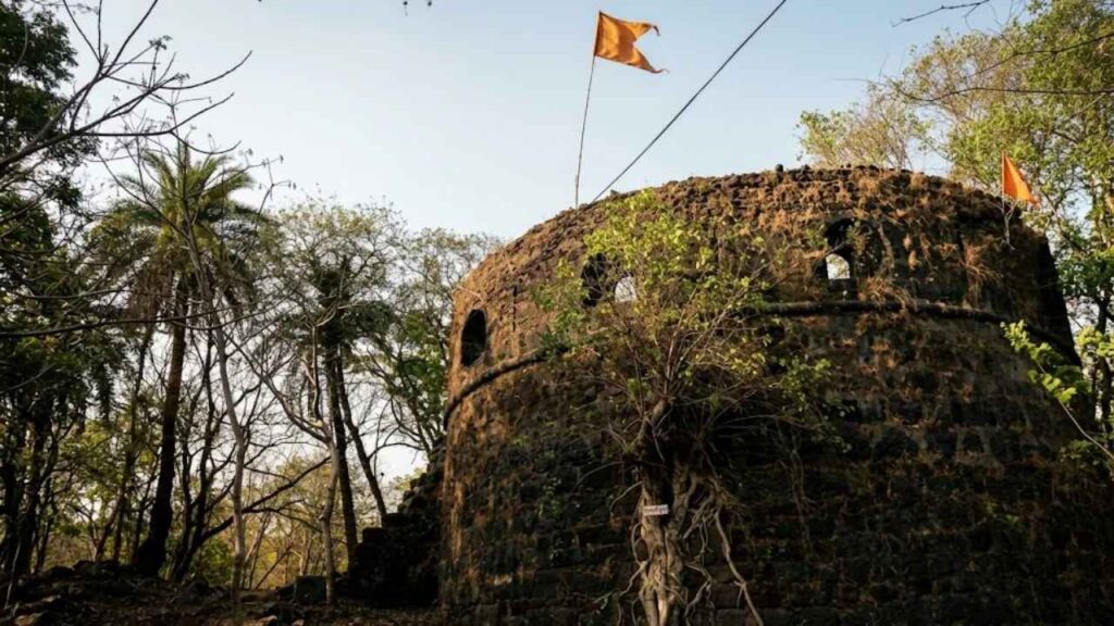
Belapur Fort once watched boats climb Panvel Creek. Today it watches traffic.
Look at Belapur Fort on a map and the story is hard to believe. The fort stands in CBD Belapur, inside Navi Mumbai’s planned grid of sectors, roads and housing societies. Yet when the Siddis of Janjira built it in the 1560s, this was an island, and the fort had a different name: Shahbaz, the falcon.
It was a fitting name. A falcon sits high, sees far and waits. Belapur Fort sat at the entrance of Panvel Creek and watched who came in. Then the land around it was reclaimed and built over, and the falcon was left standing among the buildings.
Belapur Fort in brief: Belapur Fort is a ruined 16th-century coastal fort in CBD Belapur, Navi Mumbai, Maharashtra. The Siddis of Janjira built it around 1560-70. The Portuguese held it from 1682, the Marathas under Chimaji Appa captured it in the 1730s, and the British took charge in 1817.
Belapur Fort: an island, a creek and a falcon
To understand why anyone fortified this spot, you have to picture the old geography. Belapur was once an independent island. Belapur Fort overlooked the entrance to Panvel Creek, the water route that led inland towards Panvel and, beyond it, the roads to Pune.
The book Sea Forts of India describes a fort about 400 feet long and 200 feet wide, with a small harbour only about 55 feet away. That harbour was guarded by a low wall running along the top of the riverbank. The fort most likely worked as a watchtower over the harbour, noting who arrived and who left. Boats sailing up the creek had to pass beneath its eye.
Shahbaz: the Siddi fort
The Siddis of Janjira were a sea power on the Konkan coast, and they are credited with building Belapur Fort around 1560-70, after taking control of the area from the Portuguese. At that time it was known as Shahbaz, a name explored in Live History India’s guide to Belapur’s strategic fort.
Honestly, not much is recorded about this early period. Belapur does not have the thick shelf of chronicles that Vasai or Janjira enjoy. What survives is a sequence of owners, and each handover tells you something about who wanted control of the creek.
1682: the Portuguese take over
In 1682 the Portuguese took the fort back, along with nearby territory. The Belapur Fort entry on Wikipedia records the formal annexation that year and gives the Portuguese name of the place as Belaflor do Sabaio. The fort then became one of the seven divisions subject to Bassein, the Portuguese capital in the north, and its territory reportedly included Panchena with thirty villages, Cairena with seventeen and Sabaio with seventeen. Sources spell these names in different ways.
One account describes a serious garrison of four companies of 180 soldiers and fourteen guns, kept for roughly 55 years. That figure rests on a single source, so treat it as indicative rather than settled. What is clear is that the Portuguese saw the fort as part of a chain: small posts watching the creeks, with Vasai at the centre, alongside outposts such as Tarapur Fort and Kelve Fort.
The vow that named Belapur Fort
This is the part of the story people retell. The year, according to the book, was 1733. Chimaji Appa, brother of Peshwa Bajirao I, had sworn to free the Konkan sea forts from the Portuguese and bring them into the Maratha kingdom. You can read more about Chimaji Appa’s Konkan campaign elsewhere. The book says he began with Shabaz. Before the campaign, he reportedly took an oath at the nearby Amruteshwar temple: if he won, he would garland the Shiva lingam with bel leaves (Aegle marmelos). He won, kept his promise, and the fort and the area became known as Belapur.
It is a lovely tale, and a good one to tell on site. It also deserves a caution. Some historians doubt the vow, partly because Belapur Fort reportedly fell without a hard fight. An alternative theory traces the name to the Portuguese Belaflor. The dates are also uneven: the book and the Chimaji Appa biography on Wikipedia say 1733, while other accounts say 1737. I would treat the vow as local tradition, the year as the 1730s, and the Maratha conquest as firm.
What gives the conquest its weight is the strategy around it. Chimaji Appa’s plan was to take the weaker Portuguese forts first, isolating Vasai step by step. The campaign ended with the fall of Vasai in May 1739. In that sense Belapur was an early move in a very large game. If you have read our post on Vasai Fort, you have seen where the whole sequence ends.
Under the British
The Marathas kept Belapur Fort until the British arrived. The book records that Captain Charles Gray took charge on 23 June 1817. Reports say parts of the fort were demolished around this time, which may explain why so little of the original works survives.
What remains of Belapur Fort today
The book is blunt: apart from a few features, Belapur Fort is in ruins. It lists fortification remains near the northern point, more ruins lower down, and two round towers on the south face that once held cannon. Inside are broken parapets, a low hut and a ruined well.
Other sources add a few details. A watchtower or bastion called the Tehalni Burj is the main surviving structure. The old main building holds a Shivalinga, and strong boundary walls still run around the site. CIDCO, Navi Mumbai’s development authority, runs a guest house inside the fort, and housing has crept up to its edges. A visitor in 2013 described the fort as engulfed by residential buildings, with a restored watchtower standing on a traffic island and a badly damaged bastion on a small hilltop.
Restoration has been slow and troubled. CIDCO’s plans include an interpretation centre, an amphitheatre and public amenities. Work reportedly began in 2019, and in June 2021 a square bastion tower collapsed after heavy rain, which drew criticism of the repair quality, as Citizen Matters reported on the fort’s restoration. I could not confirm what the site looks like today, and the sources disagree, so check before you go.
Local talk also mentions a tunnel from the fort to Gharapuri, the island of the Elephanta Caves. Nothing confirms it. Treat it as folklore, though the book does list a ferry ride from the Belapur jetty to Elephanta and Alibaug beach among the things to do. Current ferry services are worth confirming locally.
Why Belapur Fort still matters
Belapur is not a fort you visit for grandeur. You visit it because it shows what happens to coastal history when a city grows over it. Almost everything about its setting has changed, from the shoreline to the harbour to the island itself. What remains is a small high point that still tells you where the water used to be.
It also fits neatly into the wider story of this series. Vasai was the Portuguese capital, Ghodbunder Fort guarded the Ulhas creek, Arnala Fort held the sea approach to the north, and smaller posts like Belapur linked the system together. Read the forts one after another and the Konkan coast starts to look less like scattered ruins and more like a connected map.
How to reach Belapur Fort
Belapur Fort is in CBD Belapur, about 28 to 30 km from Mumbai.
- By rail: CBD Belapur on the Harbour Line is the nearest station. The book says the fort is about a kilometre away, while other sources put it at two to three kilometres. An auto-rickshaw is the easy option.
- By road: The book’s route runs from Mumbai along the old NH4 to CBD Belapur, then turns off at Konkan Bhavan towards the fort. Palm Beach Road and Uran Road are also used to reach the site.
- By air: Mumbai is the nearest airport, roughly 45 km away according to the book.
Best time to visit Belapur Fort and practical tips
The book says the fort can be visited all year. Another guide suggests October to March for cooler weather. The monsoon deserves care: wet stone and overgrown paths are never safe on a ruin, and the 2021 collapse happened in heavy rain.
- Check access first. Wikipedia lists the fort as not open to the public, while some travel sites quote 8:00 AM to 6:30 PM and different entry fees. Ask locally or contact CIDCO before you go.
- Allow one to two hours. The site is small and works best as part of a Belapur outing.
- Stay off damaged bastions and avoid pushing through thorny undergrowth.
- Respect the neighbourhood. This is a living area with homes and offices around the fort.
- Carry water and go early or late in the day, when the light is softer.
What to see near Belapur Fort
The book points to the Belapur jetty. Travel listings also suggest Parsik Hill, the Nerul Balaji Temple and the Belapur mango garden, and, in the monsoon, the Pandavkada waterfalls in Kharghar, about 15 km away.
Final thoughts: a falcon among the buildings
Belapur Fort will not overwhelm you. It has no great gates, no dramatic sea cliff, and its best-known story may be more legend than record. But there is something quietly moving about a fort that kept its place while everything around it was rebuilt. It watched a creek that is no longer there, and it still marks the spot.
Save this post, share it with a fellow traveller, and stay tuned for the next fort in the series.