
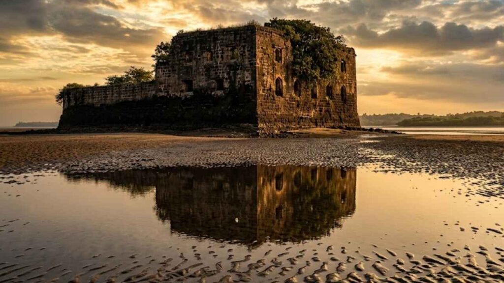
The sea had gone down, and a wide stretch of wet sand sparkled in the afternoon sun. Further out on the Kelva Beach, a small, dark shape was visible in the distance, sitting on a rock where Danda Creek converged with the Arabian Sea. This was the Alibaug Fort, a small outcrop that rose and fell with the tides. We waited for low tide, watching the water slowly recede to expose a path across the sand and tidal flats. The walk to the fort was unlike any other approach to a fort I had seen before. There was no paved road, no grand gateway, and no line of shops or signs. Just the sea, the sand, and a small, irregular structure rising from the rock ahead.
As we drew closer, the fort’s unusual design became clear. It was small, almost boat-shaped, with low walls and a handful of cannon openings. The main entrance was not at ground level but elevated well above the base, accessible historically by a movable ladder or temporary platform. There was also a lower gap in the ramparts, shaped by wave action, that added another layer to its access system.
What struck me most was not the size of the fort, but its relationship with the sea. It had two entrances associated with the tides, one linked to high tide conditions and the other to low tide. This was a fort that could only be visited when the sea allowed it, a small coastal battery whose entire existence was shaped by the rhythms of Danda Creek and the Arabian Sea.
A fort shaped like a boat
Alibaug Fort is small and has an irregular plan. Historical descriptions note its unusual, boat-like shape, built to fit the narrow rock at the creek mouth.
The fort’s layout is not a neat rectangle or square. It follows the contours of the rock, with low walls rising just enough to mount guns and create a small protected platform. Its size means it could never have held a large garrison. It was designed for a small crew, a few guns, and a clear line of sight over the water.
From a distance, the fort looks like a dark shape against the creek and sea. Up close, it feels more like a fortified battery than a full fort.
Five cannon openings and a small battery
The fort is described as having five cannon openings, arranged along its ramparts. These openings allowed guns to fire towards the creek, the sea, and the approaches from different directions.
This matches its role as a coastal battery rather than a major stronghold. It was not meant to withstand a long siege or house a large force. It was meant to control a narrow, important point where water traffic passed between the creek and the open sea.
The small number of guns and the limited space inside the walls reinforce the picture of a compact, purpose-built outpost.
Two tidal entrances and an elevated main entrance
The most unusual feature of Alibaug Fort is its access system.
The fort has two entrances associated with the tides. One entrance is linked to high tide conditions, the other to low tide. This reflects the reality of its position on a rock surrounded by tidal water.
The main entrance is not at ground level. It is elevated, roughly ten feet above the base of the fort. Historically, this entrance was accessed using a movable ladder or temporary platform that could be raised or removed when needed.
There is also a lower gap in the ramparts, formed or widened by wave action, at about five feet above the base. This lower opening, together with the elevated entrance, creates a layered access system that responds to the sea level and the fort’s defensive needs.
This design makes sense for a small, exposed outpost. When the sea was high, the fort could limit access. When the tide was low, movement across the sand and into the lower openings became possible.
Where is Alibaug Fort?
Alibaug Fort stands at the mouth of Danda Creek, near Kelva Beach in Palghar district, Maharashtra. It is a small sea fort built on a rock where the creek meets the ocean.
Online, it is most often referred to as Kelva Pankot, Kelva Beach Fort, or Paankot/Alibaug Fort at Kelve Beach. The name Alibaug Fort is used locally in some travel accounts, but it should not be confused with the much larger Kulaba Fort in Alibaug town.
The fort’s position is strategic. From its rock, it could watch both the creek and the open sea, monitor small boats, and support other coastal positions in the Kelve-Mahim belt. It is not a large fort, but its location made it useful.
Alibaug Fort and Kulaba Fort in Alibaug town
This is not the big Kulaba Fort in Alibaug town. The Alibaug Fort described here is a tiny, almost forgotten sea outpost near Kelva Beach in Palghar, locally known as Alibaug Fort, Kelva Pankot, and Kelva Beach Fort.
Kulaba Fort in Alibaug is a larger, well-known fort associated with the historic Alibaug town and the Kolaba Island fortifications. The Alibaug Fort at Kelva is a separate, much smaller structure at the mouth of Danda Creek, whose access depends on the tide.
Keeping these two distinct is important for anyone planning a visit or researching the site. They belong to different locations, different historical contexts, and different visitor experiences.
Portuguese watch post at Danda Creek
Alibaug Fort fits into the broader Portuguese strategy along the north Konkan coast. The Portuguese built a network of small forts, batteries, and watch posts to protect trade routes, monitor coastal movement, and support larger centers like Vasai.
Danda Creek was one of the many waterways that connected the coast with the interior. A small fort at its mouth could watch boats entering or leaving the creek, signal to other posts, and provide a first line of coastal control.
The fort’s boat-like shape, its five cannon openings, and its elevated entrance all point to a compact, functional design. It was not meant to impress. It was meant to work.
Alibaug Fort in the Kelve-Mahim coastal network
Alibaug Fort should be understood as part of the same coastal defense landscape as Kelve Fort, Mahim Fort, Shirgaon Fort, and Tarapur Fort. Together, these positions helped the Portuguese observe and control the coastline.
Kelve Fort, the land-based ruin near the beach, and Alibaug Fort, the tidal outpost at the creek mouth, complemented each other. One watched the shore and the plantation side. The other watched the creek and the sea.
When the Marathas under Chimaji Appa campaigned against Portuguese possessions in 1739, they targeted this entire network. While the detailed history of Alibaug Fort’s capture is not as well documented as that of Vasai or Tarapur, its position means it would have been part of the same coastal realignment.
Panburuj and the wider creek defenses
Near Alibaug Fort stood another small coastal battery known as Panburuj. This position added another layer of defense at the creek mouth, working together with the fort to control the waterway.
Panburuj and Alibaug Fort together created a small but effective system. One could fire across the approaches; the other could watch and respond to movement in the creek and along the shore. Their combined presence made the mouth of Danda Creek a monitored and defended point.
Today, Panburuj is not as prominently discussed as the fort itself, but its historical role helps explain why such a small outpost was considered worth building and maintaining.
Visiting Alibaug Fort at low tide
The most common way to visit Alibaug Fort is at low tide, when the sea recedes and exposes a path across the sand and tidal flats.
From Kelva Beach, you can see the fort as a small shape in the distance. As the tide goes out, a wet-sand approach becomes visible. You walk across the exposed ground, sometimes through shallow water, until you reach the rock on which the fort stands.
The experience is unusual. You are not walking up a paved path or through a gate. You are crossing a natural tidal zone that changes with the sea. The fort seems to appear and disappear with the water level.
At low tide, you can explore the base of the walls, see the lower gap in the ramparts, and appreciate how the fort’s design responds to the tides. The interior is small and open to the sky, with little in the way of preserved structures.
Access at high tide and by boat
At high tide, the low-tide path is submerged. The same ground that was walkable a few hours earlier disappears under water.
In these conditions, the fort can only be approached by small local boats, if conditions allow. Even then, landing can be difficult because of the rock, waves, and the fort’s elevated entrance.
This tidal dependence is central to the fort’s character. It is not a site you can visit at any time. You must plan around the sea.
What remains at Alibaug Fort today?
Alibaug Fort is in a ruined state. The walls are low, the interior is open, and there are no intact buildings or grand structures.
What you can see today includes:
- The irregular, boat-shaped outline of the fort.
- Low ramparts with five cannon openings.
- The elevated main entrance, roughly ten feet above the base.
- A lower gap in the walls, around five feet above the base, shaped by wave action.
- The rock platform on which the fort stands.
- Clear views of Danda Creek and the Arabian Sea.
- The tidal flats that appear and disappear with the water level.
The fort is not maintained as a major tourist monument. It is a heritage fragment, best visited by those interested in coastal history, unusual fort designs, and quiet, offbeat sites.
Alibaug Fort and Kelve Fort are different forts
This distinction is important because the names are often confused.
Kelve Fort is the small, heavily ruined Portuguese-era fort near Kelva Beach, hidden among Suru trees and accessible by land throughout the year.
Alibaug Fort, or Kelva Pankot, is the separate, tiny sea fort at the mouth of Danda Creek. It is island-like, tidal, and can be visited on foot only at low tide or by boat at high tide.
They belong to the same coastal defense system but are not the same structure.
For additional background on this site, you can also refer to this Kelva Pankot island fort information page maintained by local sources.
Kelva Beach and the setting around the fort
Kelva Beach is a long, relatively peaceful stretch of sand in Palghar, known for its Casuarina or Suru trees and relaxed atmosphere.
Alibaug Fort sits just offshore from this beach, at the point where Danda Creek meets the sea. The beach provides the starting point for the low-tide walk, while the creek and ocean form the fort’s natural moat.
The setting is dramatic in its own quiet way. From the beach, you can see the fort as a small silhouette against the water. From the fort, you can see the curve of the beach, the mouth of the creek, and the open sea beyond.
How to reach Alibaug Fort
By rail: The nearest practical rail access is Palghar or Kelva Road station. From there, take a bus, auto-rickshaw, taxi, or private vehicle towards Kelva Beach.
By road: Kelva Beach is accessible by road from Palghar, Mahim, Shirgaon, and other north Konkan coastal towns. From Mumbai, drive north towards Palghar and then take the local road towards Kelva Beach.
From Kelva Beach to the fort: Once at Kelva Beach, ask locally for directions to Kelva Pankot or Alibaug Fort at the creek mouth. Low tide lets you walk on the exposed sand and tidal flats. At high tide the approach is submerged, and boat access may be possible depending upon local conditions.
Best time to visit Alibaug Fort
The best time to visit Alibaug Fort is between October and March, when the weather is pleasant for walking and waiting for the tide. Your visit will need to be timed with the tide on any given day:
- Low tide: Best time to walk to the fort by foot through the sand.
- High tide: The low-tide path is submerged. Boat access may be possible, but landing can be difficult.
Check local tide tables, ask residents or resort staff about safe walking windows, and avoid visiting during rough seas, strong winds, or the peak monsoon.
What to see near Alibaug Fort
Alibaug Fort is best visited as part of a wider north Konkan coastal circuit.
- Kelva Beach: The main beach from which the fort is approached.
- Kelve Fort: The separate, land-based Portuguese ruin near the beach and Suru trees.
- Mahim Fort: A small creekside fort in the Kelve-Mahim coastal network.
- Shirgaon Fort: A better-preserved coastal watchtower farther north.
- Tarapur Fort: A larger Portuguese fort with a stronger documented history.
- Danda Bridge: A nearby landmark often mentioned in local sightseeing lists.
- Shitla Devi Temple: A local temple near Kelva Beach.
- Palghar: The nearest transport base for exploring this stretch of coast.
Before planning the visit, check current local details and wider beach information through this Kelva Beach travel information guide.
Practical tips for visiting Alibaug Fort
- Confirm that you are heading to Kelva Pankot/Alibaug Fort at the creek mouth, not Kelve Fort near the Suru trees.
- Ask locally about tide timings and safe walking windows.
- Footwear for wet sand, shallow water, and rock.
- Please bring drinking water and sun protection.
- Never go late at night. Go during the day.
- Don’t try the walk in rough seas, strong winds, or peak monsoon.
- Be careful of slippery rocks, changing water levels, and incoming tides.
- Do not climb on unsteady walls or into unsafe areas of the fort. Respect local fishermen, boat operators, and residents.
- Keep the beach and tidal area clean.
- Understand that this is a ruined, unprotected site, not a managed tourist monument.
Is Alibaug Fort worth visiting?
Alibaug Fort is worth visiting if you enjoy unusual heritage sites, tidal landscapes, and offbeat coastal history.
It is not a grand fort. You will not find large gateways, intact palaces, or a restored interpretation center. Its walls are low, its interior is small, and its access depends entirely on the sea.
But this is also its appeal.
Alibaug Fort tells the story of the small, functional outposts that made larger coastal systems possible. It was one watchpoint among many, helping the Portuguese observe and control the mouth of Danda Creek. Its two tidal entrances and elevated main entrance make it one of the more unusual small forts along this coast.
Visit it with the right expectations. Come for the tide, the walk, the quiet, and the curiosity of finding history on a rock that the sea covers and uncovers every day.
Final thoughts: a fort that lives with the tide
Alibaug Fort at Kelva is a reminder that not all forts are built to dominate the landscape. Some are built to live with it.
This small, boat-shaped outpost was designed around the rhythms of Danda Creek and the Arabian Sea. Its two tidal entrances, elevated main entrance, and compact form all reflect a practical response to a challenging location.
The Portuguese built it to watch the creek. The Marathas inherited it as part of their coastal campaign. Time and tide have since reduced it to a quiet ruin.
Yet that ruin still has a story to tell.
Stand on the rock at low tide, feel the water pulling back, and look towards the beach and the open sea. Then the purpose of the fort is revealed. It is not just a structure. It is a point where land, water, and history meet.
Save this post for your next north Konkan trip, share it with someone who loves hidden coastal forts, and follow the Sea Forts of India series as we continue along the coast.