
The traffic is the first surprise.
You arrive expecting a forgotten fort beside an old creek, but Ghodbunder announces itself through the restless movement of modern Thane—cars, buses, construction, apartment towers, and the impatience of the road. Then the route turns towards the hill, and the noise begins to fall away.
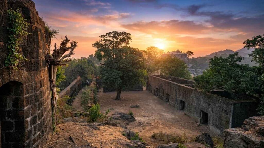
Behind the trees, the stone appears.
There is no grand approach to prepare you for it. You notice fragments first: an old wall, a dark arch, and a courtyard hidden behind vegetation. Then the fort gathers itself around you, and the modern landscape recedes just enough for another Ghodbunder to emerge—the old creekside port where Arabian horses were traded, soldiers watched the water, and Portuguese power faced the rising strength of the Marathas.
The name carries the first clue. “Ghoda” means “horse,” and “bandar” means “port.” Long before roads and buildings transformed the landscape, the area was a place of animals, merchants, boats, weapons, and waiting. The Ulhas Creek was the road; the fort was its watchtower.
In the book, I describe Ghodbunder as a fort that only makes sense when you look at the water around it. From the hill, its purpose becomes clearer. It was never an isolated stone structure. It was part of a chain that included Dharavi, Nagla Bunder, Vasai, and other positions guarding the waterways of the northern Konkan.
Today, Dharavi Fort has almost vanished. Ghodbunder Fort survived.
That difference gives the visit a strange poignancy. One fort remains as walls and arches; the other survives mainly in historical references and the memory of a defensive landscape that has been swallowed by the modern city.
Read the fort from the hill
Ghodbunder Fort stands on a low hill near the Ulhas Creek, in the present-day Mira-Bhayandar and Thane region of Maharashtra.
It is not a mountain fort. There is no long climb through forest, no dramatic plateau, and no vast valley spreading below. Its importance comes from its relationship with the water.
The creek was once a route for boats, goods, soldiers, and messages. It linked the coast to inland centers and provided access to Thane, Kalyan, Vasai, and the surrounding settlements.
From the hill, defenders could observe:
- Boats moving through the creek.
- Approaches from the coast.
- Routes leading towards Thane and Kalyan.
- The lowlands around the water.
- Movement connected with trade and supplies.
- The wider network of forts protecting Portuguese territory.
The modern view is crowded with roads and buildings, but the underlying geography has not changed. The creek still curves through the landscape. The hill still offers elevation. The same location that once made Ghodbunder strategically useful continues to explain why the fort was built here.
Why does “Ghodbunder” mean “horse port”?
The history of Ghodbunder begins with trade.
The settlement is traditionally associated with the Portuguese trade in Arabian horses. Horses arrived through the port and were exchanged with merchants before being moved inland to rulers and military forces.
In a period when cavalry was central to warfare, horse trading was not a minor commercial activity. A good horse could influence the strength of an army, the mobility of a ruler, and the outcome of a campaign.
A horse port needed more than a landing place. It required:
- Boats and unloading areas.
- Water and fodder.
- Temporary enclosures.
- Traders and brokers.
- Guards and officials.
- Storage space.
- Routes into the interior.
- Protection from rival powers.
The fort helped secure this activity.
That is why the name is so revealing. Ghodbunder was not named after an abstract military idea. Its name preserves the memory of a working port, one where animals, merchants, and soldiers were part of the same system.
Walking through the fort today, it is difficult to imagine horses being led through the rooms or unloaded near the creek. But the walls become easier to understand when you remember that the fort once had to serve commerce as well as defense.
The Portuguese fort above the water
The Portuguese expanded their presence along the northern Konkan coast during the 16th century.
Their principal center in the region was Vasai, or Bassein. From there, they controlled a network of territories, ports, villages, and forts extending across the coast and inland waterways.
Ghodbunder Fort was one of the positions that supported this system.
The Portuguese used the fort to protect the horse trade, monitor the Ulhas Creek, and defend the approaches to their wider territories. Some accounts associate the fort with the Portuguese name Cacabe de Tanna, though historical spellings and descriptions vary.
Recent reports describe Ghodbunder as a Portuguese outpost intended to house about 200 soldiers and watch for attacks approaching from the Maratha side.
That detail changes how you look at the ruins. The fort was not a small watchtower with a handful of men. It was a functioning outpost with a substantial garrison, stores, rooms, animals, weapons, and daily routines.
The walls protected more than soldiers. They protected a port.
The fort’s architecture
Ghodbunder Fort has a compact, practical design.
Its walls follow the hill and enclose a central courtyard surrounded by rooms. The fort was not built to display wealth or create a grand ceremonial entrance. It was to keep people, store goods, protect animals, and control the movement.
The surviving features include:
- Stone perimeter walls.
- Arched gateways.
- A central courtyard.
- Rectangular interior rooms.
- Defensive projections and bastions.
- Narrow passages.
- Storage spaces.
- Possible stables or horse-trading rooms.
- A recently uncovered chamber.
- Views of the creek and surrounding lowlands.
The arches are among the most attractive features. Their curves soften the weight of the stone, while the thickness of the walls reminds you that this was a military site.
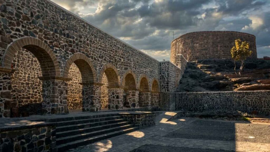
The fort’s architecture also records its changing history. The Portuguese established the original stronghold, the Marathas later occupied and adapted it, and the British used the site for administration. Not every surviving wall can be assigned confidently to one period, but the fort as a whole carries these overlapping layers.
The courtyard and the rooms around it
The courtyard is where the fort begins to make sense as a settlement.
Standing in the open center, you can see how the rooms around it were arranged. Soldiers, workers, traders, and officials would have moved through this space. Supplies would have been carried in and out. Animals may have been managed here or in adjoining rooms.
The horse-trade tradition gives the interior a vivid possibility. Reports about the restoration have referred to rectangular rooms that may have been used as granaries or for horse trading. The exact use of every room has not been conclusively established, so it is best to treat these interpretations as possibilities rather than certainties.
This uncertainty does not weaken the site. It makes the fort an archaeological landscape rather than a completed story.
The walls tell us what survived. Historical context helps us imagine what disappeared.
The recent Ghodbunder Fort restoration report provides additional context about the conservation work and the fort’s newly exposed structures.
A hidden room beneath the Ghodbunder fort
The most intriguing recent discovery at Ghodbunder Fort came during restoration work.
Workers found a chamber-like structure beneath the existing ground level near the entrance or rear portion of the fort. Reports describe a roughly square room measuring about 3.3 metres by 3.3 metres, with arched features and lime-plastered walls. Parts of it had been filled with rubble.
The room immediately generated speculation.
Could it have been a concealed passage? A storage chamber? A defensive trap? A hidden exit? Some reports suggested the possibility of a chor darwaza, or concealed rear entrance, while others considered whether it might have functioned as a deceptive entrance intended to confuse attackers.
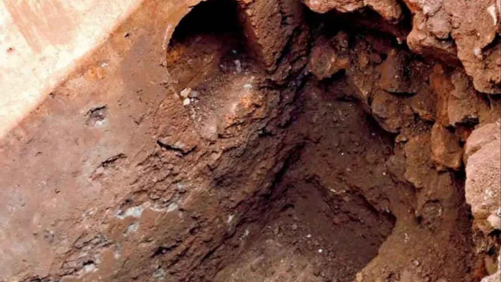
At present, its exact purpose remains uncertain.
That is important. It is tempting to turn every underground room into a secret tunnel leading to Vasai, but there is no reason to present that as established fact. The chamber is fascinating precisely because it raises questions that archaeology may not yet have answered.
Terracotta material was reportedly found in the chamber, and restoration work made the structure accessible for visitors.
When you stand near it, the fort feels less like a finished monument and more like an archive still being opened.
The hidden-chamber discovery at Ghodbunder Fort added a new archaeological question to the site’s already layered history.
Dharavi Fort: the lost fort across the water
Ghodbunder was not defended alone.
Across the water stood a fort referred to in different accounts as Dharavi Fort, Dharavi Island Fort, Dongri Fort, or Janjire Dharavi. The names are confusing, and this site should not be automatically identified with Riwa Fort or Kala Killa in the present-day Dharavi neighborhood of Mumbai.
Unlike Ghodbunder Fort, Dharavi has little clearly visible fortification today. Its importance survives mainly through references to the defensive network around Ghodbunder, Thane Creek, Salsette, and Vasai.
The purpose of such a position would have been to monitor movement across the water and support neighboring forts. Ghodbunder, Dharavi, and Nagla Bunder formed part of a chain of river and creek defenses protecting routes between the coast and the interior.
During the Maratha campaign against the Portuguese, Dharavi and Nagla Bunder were captured along with Ghodbunder. The objective was not simply to seize a single hill fort. It was to dismantle the connected Portuguese system that protected Vasai.
Very little remains that a visitor can confidently identify as Dharavi Fort today.
That absence is part of the story. Forts disappear when waterways change, settlements expand, stone is reused, and military functions become irrelevant. Some sites survive as walls. Others survive only in maps, names, and historical references.
Dharavi is the key to understanding the landscape around Ghodbunder.
The network around Ghodbunder
A larger chain of forts and fortified positions protected the waterways near Ghodbunder.
Accounts connect the region with:
- Ghodbunder Fort
- Dharavi Fort
- Nagla Bunder
- Vasai Fort
- Gaimukh Fort
- Durgadi Fort
- Other landing points and smaller watch posts
These positions did not all serve the same purpose. Some watched rivers. Others guarded landing areas, ports, creek mouths, or routes towards major strongholds.
Together, they supported:
- Surveillance.
- Communication.
- Protection of trade.
- Movement of troops.
- Control of boats.
- Storage and supply.
- Tax collection.
- Defense against rival powers.
This network is why Ghodbunder should not be described as an isolated Portuguese fort. Its strategic importance came from its connections.
The hill, the creek, the horse port, the nearby forts, and the route to Vasai all formed a single military and commercial landscape.
Shivaji Maharaj’s failed attempt
The Portuguese position at Ghodbunder was not uncontested.
Shivaji Maharaj reportedly attempted to capture the fort in 1672, but the Portuguese defenders resisted the attack.
The failed attempt shows that Ghodbunder was not an easy target. Its hilltop position, walls, garrison, and connection with the water gave the defenders several advantages.
For the Marathas, capturing the fort would not have been a mere capture of a small stronghold. It would have opened a route into the Portuguese defense network and threatened the waterways leading towards Vasai.
For the Portuguese, holding Ghodbunder helped protect the inland side of their northern territories.
The fort remained contested because the creek mattered to both sides.
Chimaji Appa and the Maratha victory
The decisive change came during the campaign led by Chimaji Appa.
In 1737, Maratha forces captured Ghodbunder Fort from the Portuguese. The event formed part of the wider campaign against Portuguese positions around Vasai and the northern Konkan.
The Marathas captured not only Ghodbunder Fort but also other positions connected with the waterways, including Dharavi and Nagla Bunder. The campaign weakened the Portuguese ability to move troops, supplies, and messages outside Vasai.
The capture of Ghodbunder achieved several things:
- It placed the Ulhas Creek under Maratha control.
- It ended Portuguese authority over the horse-trading port.
- It weakened the approaches to Vasai.
- It reduced the strength of the Portuguese waterway network.
- It helped prepare the way for the later siege of Vasai.
The fort’s title story is contained in this transition: Arab horses gave Ghodbunder its name, but the Marathas gave its history a new political direction.
For an official tourism reference, see MTDC’s Ghodbunder Fort history.
From Ghodbunder Fort to Vasai
Ghodbunder’s capture was one movement in a much larger campaign.
Vasai was the center of Portuguese power in the north Konkan. Smaller forts protected its approaches, monitored the waterways, and helped maintain communications with surrounding settlements.
Once these positions fell, Vasai became more vulnerable.
The sequence was not simple or immediate. Portuguese resistance remained strong, and Vasai itself was a major fortified city. But each captured outpost reduced the area in which Portuguese forces could operate freely.
The Maratha campaign eventually led to the fall of Vasai in 1739. The Portuguese lost their northern headquarters, and the balance of power along the coast changed permanently.
Ghodbunder matters because it helps explain how that larger victory became possible.
Ghodbunder Fort under Maratha rule
After the capture, the fort became part of the Maratha military and administrative system.
The Marathas inherited a fort that already had useful walls, rooms, water access, and a commanding position. They could adapt it rather than abandon it.
This is one of the recurring patterns in the forts of the western coast. Buildings often outlive the rulers who commissioned them. A Portuguese wall could become a Maratha wall. A colonial outpost could become a British office. The strategic value of the hill remained even when the political map changed.
At Ghodbunder, the Marathas could continue monitoring the creek and routes towards Thane and the coast.
The fort’s history was no longer only Portuguese, but its earlier layers remained embedded in the structure.
The British period
Ghodbunder later came under British control.
Accounts describe the fort as being used by the East India Company and as a district headquarters for the Thane region.
This administrative use was different from the fort’s earlier role as a contested Portuguese outpost. The British inherited a structure whose strategic purpose had changed, but whose rooms and walls were still useful.
The fort offered:
- Enclosed offices.
- Elevated ground.
- A secure compound.
- Access to roads and waterways.
- A visible administrative presence.
With the changing routes of transportation and political boundaries, the fort gradually lost its military significance. The city moved around it, while the fort itself became less central to everyday life.
Walls that once watched for enemy boats eventually watched the slow growth of roads, villages, and suburbs.
A fort swallowed by the modern city
Ghodbunder is unusual because the modern world is so close.
At many forts, the journey itself creates a separation from contemporary life. You climb through forest, cross water, or travel deep into rural country. At Ghodbunder Fort, the separation is thinner.
The fort sits within the urban expansion of the Mumbai region. Traffic and construction are part of the approach. The landscape that once made the fort seem isolated is now crossed by highways and development.
Yet this closeness makes the visit more revealing.
You can see how quickly a strategic landscape changes. A creek that once carried horses and military supplies now exists alongside modern infrastructure. A hill that once marked the edge of a colonial outpost is now surrounded by a metropolitan region.
The fort does not transport you away from the modern city. It makes the city’s layers visible.
Restoration and rediscovery
Ghodbunder Fort has entered a new chapter through conservation and restoration work.
The Mira-Bhayandar Municipal Corporation adopted the fort for restoration, and work began around 2019. Recent reports describe a substantial project involving structural repairs, vegetation clearance, visitor improvements, and the interpretation of newly exposed spaces.hindustantimes+2
Restoration at a fort is never simply a matter of making old walls look new.
The work has to answer difficult questions:
- Which walls are original?
- Which repairs belong to later rulers?
- Which structures should be stabilized rather than rebuilt?
- How can visitors enter safely without damaging fragile remains?
- How should uncertain discoveries be explained?
- How much modern infrastructure can be added without overwhelming the site?
At Ghodbunder, the restoration has also revealed features that were hidden beneath accumulated soil and debris.
The underground chamber is the most discussed example, but the wider project has helped make the fort’s internal plan more legible.
What I found inside
In the book, I tie my experience of Ghodbunder to the sense of moving between two landscapes.
Outside, the modern city is impatient and loud. Inside, the fort slows everything down. The courtyard creates a pocket of stillness. The walls block some of the traffic noise. The arches frame small pieces of sky and vegetation.
I found myself imagining the fort at different moments in its history.
- A Portuguese soldier looks towards the creek.
- A trader waiting for horses to be unloaded.
- A messenger carrying news from Vasai.
- A Maratha force preparing to cut the fort off from the surrounding network.
- A British official using rooms that had once stored supplies or housed soldiers.
The fort does not provide a complete answer to these imagined scenes. That is not its job. It gives you enough stone, space, and landscape to ask the questions.
The most compelling parts are often the simplest ones. A worn arch, a narrow room, a broken wall, or a view of the creek can be more revealing than a restored facade.
What can you see today?
Ghodbunder offers a concentrated heritage visit.
Look for:
- The hilltop position.
- The surviving perimeter walls.
- Arched entrances.
- The central courtyard.
- Rectangular interior rooms.
- Defensive projections and bastions.
- Possible horse trade or storage spaces.
- The restored chamber.
- Terracotta material associated with the chamber.
- Views towards the Ulhas Creek.
- Repairs that reveal the fort’s conservation history.
- The contrast between the historic structure and the modern city.
The fort is dramatically greened by the monsoon. In the dry season, the walls and room layouts are easier to study.
Access to individual areas may change as restoration continues. Follow local instructions and do not enter restricted sections.
How to Reach Ghodbunder Fort?
From Thane: Path to the village of Ghodbunder. Depending on your point of origin, you may use buses, taxis, auto-rickshaws, and private vehicles.
On Mira Road and Bhayandarpur: Continue by road to Ghodbunder. Auto-rickshaws, buses, taxis, and app-based cabs may be available, although travel time depends heavily on traffic.
From Mumbai: Visitors from Mumbai can travel through the western suburbs towards Mira Road and continue to Ghodbunder. Plan extra time during peak hours.
Local directions
Ask for Ghodbunder Fort, not just Ghodbunder Road. The fort is near the village and creek area, and local directions may be needed for the correct entrance.
Check current opening arrangements before travelling, particularly if restoration work or local events affect access.
Best time to visit
The most comfortable time to visit is generally from October to March.
Early morning and late afternoon are best for walking and photography. It can be warm at midday on the hilltop, and some areas have little shade.
The monsoon makes the fort green and atmospheric, but it can also bring:
- Slippery stone.
- Muddy paths.
- Waterlogging.
- Dense vegetation.
- Reduced visibility.
- Temporary access restrictions.
Wear shoes with good grip and avoid climbing walls or entering uncertain spaces in wet weather.
Practical tips
- Check current opening and restoration conditions.
- Carry drinking water.
- Wear shoes suitable for uneven stone.
- Use sun protection.
- Visit during daylight.
- Take care around walls, edges, arches, and underground.
- Do not climb damaged structures.
- Do not enter closed areas.
- Do not remove stones, terracotta, or other material.
- Avoid writing on the walls.
- Respect conservation efforts and signage
- Watch children near openings and uneven surfaces.
- Keep the courtyard and the area around it clean.
- Ask permission before photographing local residents or private spaces.
The vanished fort across the water
Dharavi Fort deserves a final return because it changes how Ghodbunder is understood.
Without Dharavi, it is easy to imagine Ghodbunder as a single fort built on a hill. With Dharavi, the landscape becomes larger. The creek becomes a defended route. The opposite bank becomes part of the same military picture. Nagla Bunder becomes another link.
The history of Dharavi is uncertain in places, and the site should not be described with more confidence than the evidence allows. Different accounts use different names and locations, and the surviving remains are minimal.
But uncertainty does not make the site irrelevant.
Many forts disappear before historians or conservation agencies can document them properly. Their traces remain in place names, old maps, local memories, and references in the histories of larger forts.
Dharavi’s absence is therefore an important part of Ghodbunder’s story. It reminds us that the fort we can see today was once one element in a much larger waterway system.
Is Ghodbunder Fort worth visiting?
Ghodbunder Fort is worth visiting if you enjoy forts with layered histories rather than only dramatic scenery.
It does not have Vasai’s vast ruined city or Arnala’s boat ride. It is not an isolated coastal monument. Its appeal lies in the way several histories meet in one compact place:
- Arabian horse trading.
- Portuguese expansion.
- Creekside commerce.
- Maratha military campaigns.
- The capture of Ghodbunder in 1737.
- The fall of Portuguese power around Vasai.
- British administrative reuse.
- Recent restoration.
- The uncertain memory of lost forts such as Dharavi.
The visit is especially rewarding if you look beyond the surviving walls.
Stand in the courtyard and imagine the port below. Look down the creek and imagine boats coming with horses and supplies. Think of Ghodbunder not as a lonely fort but as a working part of a network.
Final thoughts: from horses to victory
Ghodbunder began as a port shaped by movement.
Arabian horses arrived by water. Merchants negotiated. Soldiers watched the creek. Portuguese officials protected a commercial route that was also a military frontier.
The fort grew from that need.
Its hilltop position allowed the Portuguese to monitor the Ulhas waterway and defend the approaches to Vasai. Across the water, Dharavi and other positions helped create a connected defensive landscape. In 1737, Chimaji Appa’s forces captured Ghodbunder as part of the Maratha campaign that would eventually break Portuguese power in the northern Konkan.
Later, the fort became Maratha, then British, then neglected, and finally the subject of restoration and archaeological curiosity.
Today, the road outside is loud, but the courtyard inside is quiet.
The fort’s walls still hold the memory of horses, traders, soldiers, rulers, and rival empires. They also preserve a warning: the history of a landscape is often larger than the ruins that survive.
Ghodbunder is not only a fort to visit. It is a place to reconstruct—to look across the water, connect the vanished positions, and understand how a small hill above a creek could become part of a much bigger story of trade, war, and victory.
Save this post for your next heritage outing, share it with someone who enjoys forgotten forts near Mumbai, and follow the Sea Forts of India series as we continue along the coast.