
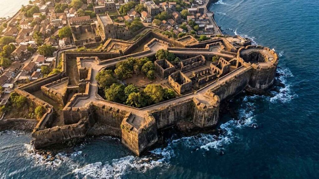
The first thing you notice about Vasai Fort is its scale.
This is not a small coastal outpost that can be explored in half an hour. The walls stretch across a broad landscape, enclosing the remains of churches, convents, homes, administrative buildings, warehouses, wells, courtyards, and military structures. Palm trees rise above broken arches, roots push through old masonry, and grass covers spaces where streets and houses once formed a busy colonial city.
Vasai Fort feels less like a single monument and more like an abandoned world.
Today, the site stands in Vasai in Maharashtra’s Palghar district, north of Mumbai. Historically, it was known as Bassein, Baçaim, or Fortaleza de São Sebastião de Baçaim. Under Portuguese rule, it became the center of a powerful northern province, controlling maritime routes, trade, shipbuilding, settlements, and a chain of forts along the Konkan coast.
The fort’s history is also connected with two separate Treaties of Bassein.
The first, signed in 1534, transferred Bassein and surrounding territories to the Portuguese. The second, signed in 1802, brought Peshwa Baji Rao II into an alliance with the British East India Company. More than two centuries separate these treaties, and between them came the rise of Portuguese Vasai, the Maratha siege and conquest of 1739, and the gradual transformation of western Indian power.
Vasai Fort is therefore not only a place of ruined walls. It is a place where maritime trade, religion, warfare, empire, and political ambition met.
Vasai Fort at a glance
Where is Vasai Fort located?
Vasai Fort is located near Vasai in Palghar district, Maharashtra, north of Mumbai. It stands beside Vasai Creek and the Arabian Sea, in a strategically important coastal position.
What is Vasai Fort also called?
The fort is also known as Bassein Fort, Baçaim Fort, Fort Bassein, and the Portuguese Fort of St. Sebastian. The name Bassein comes from the Portuguese and English forms of the historic name Baçaim.
Who built Vasai Fort?
The Portuguese established the major fortified settlement during the 1530s. Construction began under the Portuguese governor Nuno da Cunha, with the main fort associated with work beginning in 1536. The complex was expanded over several decades.
Who captured Vasai Fort?
The Marathas captured Vasai in 1739 after a major campaign led by Chimaji Appa, the younger brother of Peshwa Baji Rao I.
What are the two Treaties of Bassein?
The 1534 Treaty of Bassein transferred Bassein to the Portuguese. The 1802 Treaty of Bassein was signed between Peshwa Baji Rao II and the British East India Company and helped trigger the Second Anglo-Maratha War.
What can visitors see today?
Visitors can explore massive walls, bastions, gateways, church ruins, arches, inscriptions, wells, courtyards, and views of the surrounding creek and coast. The site is largely ruined but retains the form of a fortified historic city.
A city before the Portuguese
The importance of Vasai began before the Portuguese arrived.
Its location was valuable because it combined several advantages: access to the sea, sheltered creeks, inland routes, agricultural land, and proximity to the wider maritime system of the Gulf of Khambhat and the Konkan coast. The waterways around Vasai allowed ships and smaller vessels to move between the coast and the interior.
Before Portuguese control, the region was connected with the Gujarat Sultanate and other regional powers. The Sultanate’s influence extended across important ports and coastal settlements, and Bassein was part of a wider political and commercial landscape linking Gujarat, the Konkan, the Deccan, and the Arabian Sea.
The Portuguese understood the value of the location quickly.
To control Bassein was to control more than one fort. It meant gaining a base from which they could supervise nearby islands, ports, creeks, villages, and maritime routes. It also offered a useful position between their major centers in Goa and the territories around Bombay, Salsette, Daman, and the northern Konkan coast.
The first Treaty of Bassein, 1534
The first Treaty of Bassein was a significant event in the region’s history.
In 1534, Sultan Bahadur Shah of Gujarat ceded Bassein and surrounding territories to the Portuguese. The agreement followed Portuguese military and naval pressure along the western coast and gave Portugal control of a strategically important coastal zone.
This treaty should not be confused with the later 1802 Treaty of Bassein. The 1534 agreement involved the Portuguese and the Sultan of Gujarat. The 1802 agreement involved Peshwa Baji Rao II and the British East India Company.
Under Portuguese control, Bassein developed into one of the most important centers of Portuguese power in western India. The settlement became a military headquarters, a naval base, a commercial center, and a major site of Catholic missionary activity.
The treaty gave the Portuguese a territorial base. The fort and city that followed transformed that political gain into a durable coastal empire.
Portuguese construction begins.
The Portuguese began constructing and strengthening the major fortifications of Bassein during the 1530s. Historical and heritage sources associate the beginning of the main fort with Nuno da Cunha and construction around 1536.
The fort was formally associated with Saint Sebastian, and its Portuguese name was linked to the fortified settlement of Baçaim. The construction spanned multiple phases. Like many major forts, Vasai developed over time as walls were strengthened, bastions were modified, buildings were added, and the settlement expanded.
The result was a fortified city rather than a simple military enclosure.
Within and around the walls were religious buildings, residences, administrative offices, storage areas, workshops, and spaces connected with trade and maritime activity. The fort’s defenses protected this entire urban system.
Its architecture combined European military ideas with local materials, labor, climate, and terrain. The walls were designed for artillery warfare, while the settlement inside them had to function as a permanent city in a tropical coastal environment.
Baçaim: capital of the northern Portuguese province
During the Portuguese period, Bassein became the center of the Northern Province of Portuguese India.
This province included a network of territories and settlements extending across the northern Konkan. Portuguese influence reached places such as Salsette, Thane, Bandra, Mahim, Vasai, Daman, and other coastal positions. The exact extent of effective control changed over time, but Bassein remained one of the principal administrative and military centers.
From Vasai, the Portuguese could coordinate:
- Coastal defense.
- Maritime patrols.
- Trade.
- Shipbuilding.
- Tax collection.
- Missionary activity.
- Relations with local villages and landholders.
- Military support for smaller forts.
- Movement of troops and supplies.
This helps explain why the Marathas later treated Vasai as the central objective of their campaign. Capturing a small outpost could weaken one part of the Portuguese network. Capturing Vasai threatened the network’s command center.
Trade, shipbuilding, and maritime power
Vasai was not built only for war.
The settlement benefited from its access to timber, creeks, agricultural areas, and the sea. Its shipbuilding activity was especially important because Portuguese power depended on maintaining vessels for transport, trade, patrol, and warfare.
The surrounding creeks provided sheltered waters where boats could move, anchor, load supplies, and connect with inland settlements. The port also sat within a maritime world that linked western India with the Arabian Peninsula, East Africa, the Persian Gulf, Goa, and Southeast Asia.
The fort protected the infrastructure that made this activity possible.
Warehouses stored materials and goods. Workshops backed military and maritime work. Administrative buildings handled taxation, provisioning, and governance. Religious institutions served the Portuguese population and missionary communities.
Vasai’s power therefore came from a combination of fortification and urban activity. The walls mattered because there was a city behind them.
A fortified city behind the walls
The ruins inside Vasai Fort reveal a complex urban settlement.
Walking through the site, visitors encounter more than defensive masonry. The remains point to a city that once included:
- Churches and chapels.
- Convents and religious residences.
- Houses for Portuguese officials and settlers.
- Military quarters.
- Warehouses and storehouses.
- Administrative buildings.
- Hospitals and charitable institutions.
- Wells and water facilities.
- Courtyards and internal streets.
- Workshops and service areas.
- Waterfront structures and landing points.
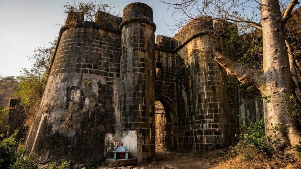
The city’s original appearance would have been very different from the green landscape seen today. Streets would have carried soldiers, traders, clergy, workers, sailors, and residents. Bells would have marked religious life. Boats would have moved along the creek. Officials would have managed the surrounding province from within the fortified settlement.
The present-day ruins are quiet, but they preserve the outline of that former activity.
Churches, convents, and religious life
Religious architecture is among the most striking features of Vasai Fort.
The Portuguese period brought churches, chapels, convents, and religious institutions into the fortified city. Orders such as the Franciscans, Jesuits, Augustinians, and other Catholic communities played roles in the religious and social life of the settlement.
The ruins preserve traces of:
- Large church facades.
- Arched entrances.
- Thick walls.
- Stone columns.
- Roofless naves.
- Side chapels.
- Tombs and memorial slabs.
- Carved details.
- Decorative fragments.
- Bell tower remains.
The churches were more than houses of worship. They were also landmarks, institutions, burial places, and symbols of Portuguese authority.
Their presence is a sign that Vasai was to be a permanent city of the colonizers. A temporary military camp would not have required such an extensive religious landscape.
The ruins also reveal the effect of time. Tropical vegetation has entered the buildings, roots have widened cracks, and open roofs have allowed rain to work on the masonry. Some structures remain recognizable, while others survive only as fragments.
The architecture of the fort
Vasai Fort was designed for a period when artillery had transformed warfare.
Unlike older hill forts that depended primarily on steep slopes and high vertical walls, coastal artillery forts needed thick, durable walls, projecting bastions, controlled gateways, and firing positions that could cover approaches from different directions.
The fort’s defensive features include:
- Long curtain walls.
- Projecting bastions.
- Gun openings.
- Sea-facing defenses.
- Creek-facing defenses.
- Landward walls.
- Strong gateways.
- Internal military zones.
- Watch positions.
- Water access points.
The walls were more than walls. They were platforms from which defenders could watch for movement and fire on approaching forces.
The water around them was also a natural defense. Vasai’s creek and coastal position made a direct approach difficult, especially for an attacking army that had to move troops, artillery, supplies, and siege equipment across a challenging landscape.
The fort’s strength came from the relationship between masonry, water, terrain, and the city inside.
The bastions and defensive line
The bastions gave defenders angled firing positions along the perimeter.
From a bastion, guns could cover sections of the wall and the ground approaching the fort. The arrangement reduced blind spots and allowed defenders to fire along the face of an attacking force rather than only directly ahead.
Some bastions are better preserved than others. Several are partly broken, while others still provide impressive views over the surrounding landscape.
The walls were comparatively low by the standards of some hill forts, but their mass and thickness were suited to artillery warfare. Recent descriptions of the fort emphasize thick walls and distinctive pointed or angular bastions designed to withstand cannon fire and resist assault.
The fort’s defensive character becomes most apparent when viewed from the outside. From within the ruins, vegetation can make the site feel open and peaceful. From the walls, however, the scale of the perimeter becomes clear.
Gates and entrances
The gateways were among the most vulnerable points in any fortified city.
Vasai’s entrances had to allow controlled movement for residents, troops, traders, carts, and supplies while remaining defensible during an attack. Gateways were therefore supported by thick masonry, changes in alignment, elevated positions, and nearby firing points.
Today, some entrances survive as monumental arches, while others are damaged or partly obscured by vegetation. The approach to a gate can still create a powerful impression because the visitor passes from the modern landscape into the enclosed world of the fort.
The ruined gates also show the difference between a fort designed for everyday urban life and a small isolated battery. Vasai’s entrances had to serve a city. They were not merely openings through a wall.
Why the Marathas targeted Vasai
By the 18th century, Portuguese power in the northern Konkan had become an obstacle to Maratha expansion.
The Portuguese held a chain of coastal territories and forts, including important settlements around Vasai and Salsette. They affected trade, movement, taxation, and access to the sea.
Vasai was particularly important because it served as the center of the Portuguese system. As long as Vasai remained secure, smaller Portuguese positions could receive support and coordination.
For the Marathas, the objectives were strategic as well as political:
- Remove Portuguese control from the north Konkan.
- Secure the coast and surrounding territories.
- Protect Maratha trade and movement.
- Reduce a European military presence near important centers.
- Gain control of forts, ports, and creeks.
- Break the administrative heart of Portuguese power.
The campaign was therefore not a single isolated attack on one fort. It was a systematic effort to dismantle a coastal network.
Chimaji Appa’s campaign
The campaign against the Portuguese was led by Chimaji Appa, the younger brother of Peshwa Baji Rao I.
Before the final assault on Vasai, Maratha forces targeted Portuguese positions in the surrounding area. The Maratha forces captured or weakened forts and settlements around the northern Konkan, including locations connected with the Vasai defense network.
Arnala, Mahim, Kelve, Shirgaon, Tarapur, and other coastal positions formed part of the wider strategic environment. Their capture reduced the Portuguese ability to reinforce Vasai and restricted movement between their northern possessions.
The Maratha campaign combined land operations, artillery, engineering, and control of surrounding routes. The defenders had strong walls and access to water, but the fort’s wider network was gradually being compressed.
Vasai could not be treated as an isolated island of Portuguese power. Once surrounding positions were lost, pressure on the main stronghold increased.
The siege and fall of Vasai in 1739
The final campaign against Vasai was difficult and costly.
The Portuguese had a formidable fortified city, experienced soldiers, artillery, and access to the sea and creeks. The Marathas had to bring an attacking army against heavy walls while maintaining supplies and constructing positions close enough to threaten the defenses.
The siege involved:
- Encampments around the fort.
- Artillery positions.
- Trenches and approach works.
- Mining operations beneath sections of the walls.
- Attempts to breach or weaken the defensive line.
- Repeated pressure on the garrison.
- Naval and creek-side considerations.
- Negotiations as the defenses deteriorated.
The fort’s walls were built to resist cannon fire, but prolonged siege warfare could attack a stronghold in several ways. Bombardment damaged masonry. Mines could undermine bastions. The trenches allowed the attackers to advance under cover. The loss of surrounding forts reduced the defenders’ ability to obtain reinforcements.
The Portuguese fought back, but the situation became untenable.
In 1739, Vasai fell to the Marathas. The victory ended Portuguese control over their major northern stronghold and marked a major shift in the balance of power along the western coast.
The fall of Vasai was one of the most important Maratha victories in the Konkan.
It was not merely the capture of a fort. It was the takeover of a fortified city, a port, a military headquarters, and the center of an entire regional system.
The Maratha victory
The capture of Vasai was celebrated as a major achievement of the Maratha state.
Chimaji Appa’s campaign had removed the Portuguese from a position they had held for more than two centuries. It also demonstrated the Marathas’ ability to conduct a large and technically demanding siege against a European colonial power.
The victory had practical consequences:
- Portuguese power in the northern Konkan was sharply reduced.
- Maratha control over the coast expanded.
- Nearby forts and settlements changed political allegiance.
- The Marathas gained an important port and administrative center.
- European military influence near Bombay and Salsette was altered.
- The Maratha state gained prestige and strategic depth.
The fort did not become irrelevant after 1739. It remained a valuable Maratha possession and continued to serve military and administrative purposes.
Its identity, however, changed. It was no longer the heart of Portuguese Baçaim. It became a symbol of Maratha success.
Vasai under Maratha control
After the conquest, the Marathas took over the fort and its surrounding territory.
The structures built by the Portuguese remained, but the political meaning of the site changed. Administrative officers, soldiers, and local authorities now served a different power. The churches and colonial buildings were no longer at the center of Portuguese provincial rule.
The Maratha period also connected Vasai more closely with the political system centered on Pune and the Peshwa administration.
The fort’s military importance continued to depend on its coastal location. Its walls, bastions, waterways, and access to the surrounding region continued to make it valuable.
This period lasted until the larger transformation of Maratha power in the early 19th century.
The Second Treaty of Bassein, 1802
The second Treaty of Bassein is one of the most important political events associated with the site.
It was signed on 31 December 1802 between Peshwa Baji Rao II and the British East India Company. It followed the Peshwa’s defeat by forces led by Yashwantrao Holkar at the Battle of Poona in October 1802. Baji Rao II fled to Bassein and sought British military support.
Under the treaty, the British agreed to restore Baji Rao II to the office of Peshwa. In return, he accepted a subsidiary alliance that placed substantial limits on his independence and allowed a British force to be stationed in his territory.
The treaty included major concessions to the British, including:
- Acceptance of British military protection.
- Maintenance of a British subsidiary force.
- Payment or territorial arrangements to support that force.
- Restrictions on the Peshwa’s independent relations with other powers.
- British influence over the Peshwa’s foreign policy.
The treaty was deeply controversial among other Maratha leaders. The Sindhias and Bhonsles rejected the arrangement, and the agreement contributed directly to the outbreak of the Second Anglo-Maratha War.
The British used the treaty to expand their political influence across western and central India. What appeared to be an agreement protecting the Peshwa became a major step in the weakening of Maratha sovereignty.
The two Treaties of Bassein
The title of this article refers to two separate treaties with very different consequences.
| Treaty | Year | Parties | Historical consequence |
| First Treaty of Bassein | 1534 | Sultan Bahadur Shah of Gujarat and the Portuguese | Bassein passed into Portuguese control. |
| Second Treaty of Bassein | 1802 | Peshwa Baji Rao II and the British East India Company | British influence entered the Maratha political system and helped trigger the Second Anglo-Maratha War. |
The first treaty marked the beginning of Portuguese dominance at Bassein.
The second treaty marked the beginning of the end of Maratha political independence.
Between these two agreements, Vasai experienced a remarkable transformation: from a regional port under Gujarat to a Portuguese colonial capital, then a Maratha stronghold, and finally a site associated with British expansion.
British control and later decline
The Maratha defeat in the Third Anglo-Maratha War brought the wider Peshwa territories under British control in 1818.
Vasai’s military importance declined as political power, transport systems, naval technology, and administrative centers changed. The fort no longer served as the headquarters of a major independent coastal power.
Like many historic forts, it gradually lost its original function. Buildings fell down, roofs collapsed, and some of the stone was recycled or damaged. The fortified city became a landscape of ruins.
Its decline was not a single event. It happened slowly through abandonment, changing settlement patterns, weathering, vegetation, and the movement of political and commercial activity elsewhere.
The surviving walls are therefore only part of the original city. Many buildings have disappeared, while others remain as foundations, fragments, arches, or partially standing facades.
What remains at Vasai Fort today?
Vasai Fort remains one of the most impressive historic sites in the Mumbai Metropolitan Region.
The fort is large enough to reward repeated visits. On one day, a visitor may focus on the walls and bastions. On the other hand, the churches and inscriptions may become the center of attention. The surrounding landscape changes with the season, and different light reveals different details in the stone.
Visitors can see:
- Massive perimeter walls.
- Ruined gateways.
- Sea-facing and creek-facing defenses.
- Bastions.
- Cannon openings.
- Church facades.
- Roofless naves.
- Arched corridors.
- Convent remains.
- Tombs and memorial stones.
- Inscriptions.
- Wells.
- Courtyards.
- Residential ruins.
- Administrative fragments.
- Views over the surrounding creek and landscape.
The fort’s most striking feature is its scale. Even when individual structures are damaged, the extent of the city remains visible.
You can walk for a long time without seeing every section.
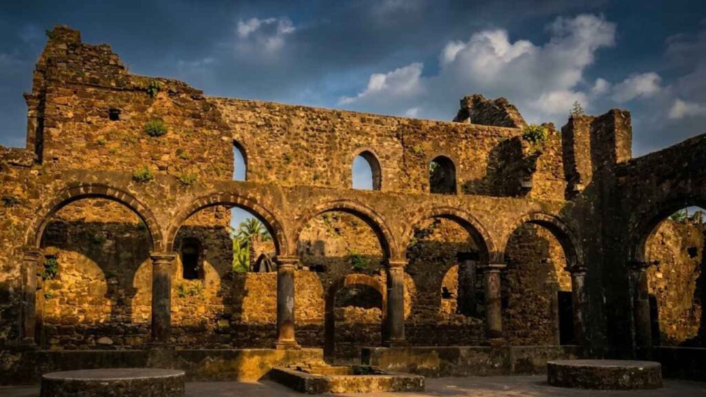
The churches as surviving landmarks
The churches provide some of the clearest visual reminders of Vasai’s former urban life.
Their facades often retain recognizable arches, doorways, wall divisions, and decorative elements. Some rise above the surrounding vegetation as if they were still active buildings, while others have been reduced to partial walls.
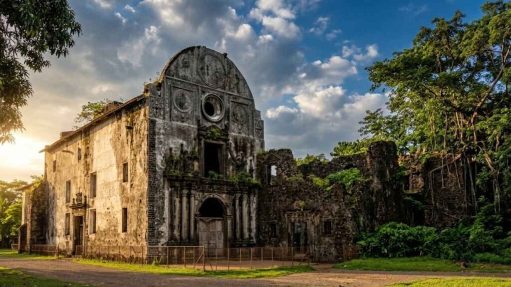
The lack of roofs creates a powerful atmosphere. Sunlight shines straight into rooms where altars, congregations, rites, and funerals once stood. Trees grow inside former chapels. Roots grip old stone. The boundary between architecture and landscape becomes difficult to separate.
The churches also help visitors understand the city’s former layout. They were not scattered ornaments. They belonged to an organized settlement with religious districts, residential areas, roads, and civic institutions.
Inscriptions, tombs, and memory
Stone inscriptions and tombs add another layer to the fort’s history.
Some inscriptions are difficult to read because of weathering, plant growth, or damage. Others remain visible enough to remind visitors that the fort was a lived city, not only a military installation.
Tombstones and memorial slabs record people connected with the Portuguese period, including officials, clergy, soldiers, and residents. Their presence provides a human dimension to the larger political story.
People often remember empires through their rulers and battles. At Vasai, the ruins also preserve traces of ordinary lives: people who worshipped, worked, raised families, served in the military, traded, travelled, and were buried within the fortified city.
A suggested walking route
Because Vasai Fort is extensive, a planned route helps.
- Start at the main entrance Begin with the main entrance or the simplest way in. Stop before you go in and note the wall thickness, surviving defensive features, and the transition from the modern settlement to the historic enclosure.
- Follow the outside walls You can walk on part of the ramparts to get an idea of the size of the fort. Look for bastions, gunports, changes in wall lineups, and views towards the creek.
- Visit the ruins of the church, then go back towards the remains of the major church and convent. Look at the facades, arches, side walls, and roofless interiors.
- Search in inscriptions and tombstones Take time to look at stone slabs and memorials. Do not touch or attempt to clean delicate inscriptions.
- Go to the wells and the courtyards These features go a long way towards explaining how a great city worked. Water storage and internal open spaces were important to the residents, soldiers, religious communities, and visitors.
- Back to the Bastions End with another bastion or section of the high wall. The views give a sense of the strategic importance of Vasai and the control of the waterways around it by the fort.
The exact route may vary depending on current access, restoration work, vegetation, and local conditions.
How to reach Vasai Fort
By train: The usual rail access is Vasai Road station on the Western Railway line. From the station, take an auto-rickshaw, taxi, bus or private vehicle towards the fort.
By road: Vasai is connected to Mumbai, Thane, Mira Road, Nalasopara, Virar, and other areas in the Mumbai Metropolitan Region. The time it takes to get around by car depends a lot on traffic, especially at the weekend and rush hour.
Local transportation: Auto-rickshaws are the preferred mode for the last leg from Vasai Road station. Confirm the destination as Vasai Fort or Bassein Fort, since the wider Vasai area contains many unrelated residential and commercial locations.
Allow enough time.
The fort is too large for a rushed visit. Allow at least two to three hours for a basic exploration. History enthusiasts, photographers, and visitors who want to study the churches and walls should consider spending half a day.
Best time to visit
The most comfortable period is generally from October to March.
Early morning is especially pleasant because the temperature is lower and the light is softer. Late afternoon can also be rewarding, particularly for photographs of the walls, churches, and palm trees.
The monsoon transforms the ruins into a lush landscape, but it also creates practical problems:
- Slippery stone.
- Muddy paths.
- Swamps.
- Dense vegetation.
- Limited visibility.
- The danger is greatest near broken walls and wells.
- If you’re visiting during monsoon, wear appropriate footwear and don’t try to climb or walk through unstable sections.
Practical tips for visiting Vasai Fort
- Wear shoes with a firm grip.
- Carry enough drinking water.
- Use sun protection during the warmer months.
- Allow several hours rather than treating the fort as a short stop.
- Visit during daylight.
- Be wary of wells, broken walls, steep edges, and thick vegetation.
- Do not climb fragile arches, bastions, or church walls.
- Do not remove stones, tiles, inscriptions, or other material.
- Avoid scratching names into the masonry.
- Keep food waste and plastic out of the ruins.
- Respect local residents and places of worship; consider hiring an expert local guide.
- Check current access conditions before travelling, particularly during the monsoon or restoration work.
Conservation challenges
Vasai Fort faces the same pressures that affect many large historic ruins.
The coastal climate exposes the masonry to salt, humidity, wind, and heavy monsoon rain. Cracks and joints fill quickly with vegetation. Roots will break through walls and destroy arches. The free movement of visitors can damage sensitive surfaces. Urban sprawl around the fort also alters the relationship between the historic site and its surrounding landscape. The fort was once a complete city connected to its waterfront, roads, and surrounding settlements. Today, modern development sits close to the historic remains.
Conservation therefore requires more than repairing individual walls. It requires protecting the larger historic environment, recording the surviving structures, controlling vegetation, improving interpretation, and helping visitors understand why the site matters.
A ruined church or bastion is not an isolated object. It is part of the larger story of Vasai as a fortified city.
Vasai and the wider coastal network
Vasai did not stand alone.
Its power depended on surrounding forts, ports, settlements, and watch posts. Arnala guarded an island position near the Vaitarna coast. Agashi served as a historic mainland position near the Vasai-Arnala region. Kelve, Mahim, Shirgaon, and Tarapur formed part of the wider coastal defense landscape farther north.
Smaller forts guarded the roads and gave warning. Larger centers such as Vasai coordinated administration, military movement, trade, and political authority.
This network explains why the Maratha campaign targeted multiple positions before and during the final struggle for Vasai. The fall of surrounding forts weakened the Portuguese system; the capture of Vasai removed its center.
What to see near Vasai Fort
Vasai Fort can be combined with several nearby historical and cultural sites:
- Agashi: A historic settlement connected with the Vasai-Arnala region, including St. James Church.
- Arnala Fort: The island fort near Virar, known as Jaldurg or Janjire Arnala.
- Kelve Fort: An overgrown Portuguese coastal ruin near Kelva Beach.
- Alibaug Fort at Kelva: Also called Kelva Pankot, a small tidal outpost at the mouth of Danda Creek.
- Mahim Fort: A smaller fort connected with the north Konkan coastal defense network.
- Shirgaon Fort: A coastal fort farther north with surviving defensive walls.
- Tarapur Fort: A larger Portuguese fort in the northern Palghar region.
- Vajreshwari: A major religious and historic destination inland from the coast.
- Tungareshwar: A forested hill and temple landscape near Vasai.
The area is especially rewarding for travelers following the history of Portuguese and Maratha coastal power.
Is Vasai Fort worth visiting?
Vasai Fort is worth visiting if you want to experience history as a landscape rather than as a single preserved monument.
You can often understand a small fort through a gateway, a bastion, and a few walls. Vasai demands a different approach. You have to walk through its ruins and gradually reconstruct the city in your imagination.
The churches show the religious life of the settlement. The bastions reveal the settlement’s military purpose. The wells and courtyards suggest everyday life. The walls explain its strategic importance. The surrounding waterways reveal why different empires wanted to control the site.
It is also one of the rare places where several major historical layers remain visible in one location:
- Gujarat Sultanate influence.
- Portuguese colonial expansion.
- Catholic religious architecture.
- Maratha military conquest.
- Peshwa political history.
- British imperial expansion.
That combination makes Vasai Fort one of the most important heritage sites in the Mumbai-Palghar region.
Final thoughts: a lost city with two treaties
Vasai Fort is often described as a Portuguese fort, but that description is too narrow.
It was a city, a port, a military headquarters, a religious center, and the administrative heart of Portuguese power in northern western India. Its walls protected not only soldiers and guns but also churches, homes, warehouses, workshops, government offices, and the people who lived within them.
The first Treaty of Bassein in 1534 brought the city into Portuguese hands. More than two centuries later, the 1802 Treaty of Bassein connected the site with Peshwa Baji Rao II’s agreement with the British East India Company. Between those two treaties, Vasai rose, expanded, resisted the Marathas, fell to Chimaji Appa in 1739, and changed political identity once again.
Today, the empire is gone, but the city has not disappeared completely.
It survives in the shape of the walls, the arches of churches, the lines of the bastions, the inscriptions in stone, and the palms growing through the ruins. Walk slowly, and Vasai begins to reveal itself—not as a single fort, but as a lost Portuguese city whose history continued long after its walls stopped being a center of power.
Save this post for your next heritage trip, share it with someone who enjoys ruined cities and coastal history, and follow the Sea Forts of India series as we continue along the coast.